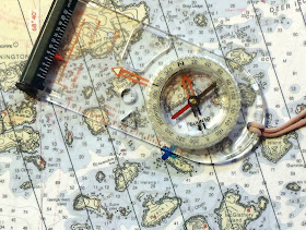
Magnetic North Lines – The Path to Happiness:
As we all know, compass needles point to magnetic north. Charts and maps are aligned with true north. They are not usually the same direction - where I paddle there is about a 16-18 degree difference. Somehow, you have to deal with this problem when trying to connect your chart to your compass. There's the old mnemonic "East is Least and West is Best" to help you convert between Magnetic and True, but when I'm out on the water, the last thing I want to be doing is math in my head; it's just too easy to make a mistake.
Some people recommend that you pre-plan your entire route (and possible route variations) ahead of time, in the comfort of your home, and prepare your chart by jotting down all the course bearings in magnetic with the crossing distances. You can do that...it's a good system...but it's not very flexible and it takes a lot of work.
I've adopted an approach that takes most of the complexity out of using a chart yet still allows a flexible approach to course selection. I prepare my charts and maps by drawing a grid of evenly-spaced parallel lines over them. The lines are oriented to run parallel to magnetic north. I usually use a spacing of half a nautical mile. This chart addition eliminates the need for a compass rose or a scale of miles on the chart section.
 |
| Chart section with magnetic north grid-lines added |
 |
| Compass and chart terms |
 |
| Align the baseplate edge along your desired course |
 |
| Turn the ring until the orienting arrow is aligned parallel to the chart lines and pointing towards magnetic north |
I estimate distances visually using the grid spacing. I know that our usual speed is about 3 knots, which is 20 minutes to cover a nautical mile. With my usual half-mile grid spacing, each grid line is about 10 minutes of paddling apart. So the crossing from Wreck Island to Bare Island in the example above looks to be about .3 miles or about 6 minutes. It's a rough approach but it's accurate enough for the crossings we usually do.
More navigational tips from Mark:
Another question I'm often faced with is the reverse: What is that island over there? This can be a problem in geographically complex areas like the one below. Imagine that we are on the north end of Bare Island (marked with a blue X). There are about 20 islands within a one mile distance of us! What's the name of that big round one over there?
 |
| From Bare Island, the view is pretty confusing! |
 |
| Transferring a hand bearing taken with the hiking compass to the chart |
You can use the same technique to locate yourself along a known line of position, such as a shoreline or a range, using a bearing on a known chart object. Take the hiking compass with the bearing on it and align the orienting arrow with the magnetic north lines as usual. Then float the compass around until a baseplate edge passes through the known object. Your position should be at the intersection of the baseplate edge line and your known line of position. You've just done a compass triangulation without any math at all!
The system is not my own invention...I learned it from a Boy Scout manual when I was much younger. I've simply extended it to the marine environment and expanded it a bit. My wife and I find it very easy to use, even when our "chart room" is our spray skirts in a bouncing kayak.
Preparing the charts:
To prepare your charts (or maps) in this way, you have a number of choices. You can use a traditional paper chart and get the lines of magnetic north from the compass rose and use parallel rules and dividers to lay out the grid.
 |
| Traditional charting tools can be used to construct the grid |
 |
| Using a custom stencil to complete the grid |
For the curious, I purchased the PhotoShop BSB converter plug-in and used it with my version of PaintShop 9 (which can use PhotoShop plug-ins) to convert all the charts I was interested in to GIF format. Then, I use MSPaint (the large size of the images seems to confuse PaintShop when copying to the clipboard) to copy the section I want (along with a piece of the miles scale) which I then paste into a layer in WindowsDraw which is a vector drawing program that also handles images. I have a bunch of parallel line grids set up in WindowsDraw. I pick one and resize it until the grid spacing appears to match the miles scale on the chart section. I then rotate the grid the number of degrees the compass rose tells me I need to align with magnetic north. I might also mark up the chart in other ways in WindowsDraw, such as add in landing spots or Lat/Lon information for GPS use. Finally, I print it out, trim it down and laminate it. Then it goes in the chart-case.

Great article. BTW, there's a new BSB converter out, so you don't have to do the command line stuff I wrote in the print charts article. It's free. Here's the goods: http://www.paddlinglight.com/articles/tutorial/noaa-marine-chart-converter/
ReplyDelete