Pages

Sunday, September 22, 2013

Birch Point through Muscle Ridge: Third Time's Rather Charming

On the beach, Muscle Ridge Islands in the distance
It was a surprisingly benign and bright day at Birch Point State Park.  A weekday, just before the 9AM opening time, but the gates were open.  We weren't alone in the park, a couple was out for a morning walk, another exploring the beach.  Mark and I were heading for Two Bush Light beyond the Muscle Ridge Islands.  (Muscle is a variant of mussel, the ridge is named for the blue mussels found there.)

It's a 1.5- 2 mile crossing to the Muscle Ridge Islands.  In the morning, our main issue was paddling almost directly into the sun.   But soon enough there were islands to distract us.   There were several granite quarries on the various islands of Muscle Ridge, and the scars of those activities are evident along the shoreline.
Also evident, is that on High Island there's someone with some real stone masonry skills.
Every time we've been to Muscle Ridge a strong current  runs northeast-southwest through the islands.  This day was no different.  So our travel from High to Pleasant was fairly swift.  We crossed under a bridge mid Hewett Island.  It was close to high as we passed under, and the water was about as high as would allow passage.
Behind the bridge was a quiet harbor.
 The seas were quiet, so we decided to look at Two Bush Light.
 The bushes which gave the isle its name are gone.  There's a fair amount of brush though.  Two Bush Island is a bird sanctuary, with no good beaches. Out on the edge of Muscle Ridge, Two Bush Light is a lonely light on a small island.  When it was manned, winters there must have been rough.  The lighthouse has been automated since 1964.  A large lighthouse keeper's home was demolished by Green Berets in 1970.   You can see a picture of the lighthouse keepers house at Wikipedia.  Demonstrating it's dual function as a bird sanctuary, this eagle posed for us on Two Bush Light.
Mark getting another photo
After looking at the light, we headed back through the islands.  That's where we found some of the nicest views of the trip.  Many  islands have houses or work structures.
Flag Island has an array of structures
 The small islands with Camden's hills behind were quite scenic.
Ducking between Andrews Island and the Neck was like finding ourselves in a bog.  An unexpected treat three miles off shore.  We tended to stick close to Hewett, Andrew and the Neck as we paddled, and did not find the current too stressful, other than on the eastern side of the Neck.
Behind The neck
There are two MITA islands in Muscle Ridge, we stopped at one for lunch and a break before heading in.
The current followed us most of the way across, we used a twenty degree ferry angle from Otter to Otter Ledge, and even beyond a bit.  But mostly is was just a simple paddle back, to a beach now filled with a lunchtime crowd.

Muscle Ridge is known as good place for wildlife, we did see several flocks of scoters and mergansers.  Not many seals though, although a couple trailed us to Otter Ledge. 
Seals which did not follow us
We'd been through Muscle Ridge twice before, but never noticed the lovely views we saw on this trip.  The first time storms were pending later in the day. We glided through the islands, headed in by Sprucehead Point and Waterman Beach and paddled back along the shoreline.  Sticking close to shore made sense in light of the pending storms, and it was a different area to explore, but it meant we never saw the backdrop of the Camden Mountains.
   Our second visit was on a beautiful clear-sky day, but the seas were rough and while we were out there the wind picked up.  We cut our tour short.  The views must have been there, but I didn't notice them. We worked our way across the channel from lobster buoy to lobster buoy, grateful for evidence of  progress.  As we were heading in, it seemed like every sailboat in the area was headed out to play.  We struggled forward, would see a sailboat heading through, stop to give them right of way, and blew backwards out to the islands.  Then, after the sailboat passed by gleefully, we'd begin our slog forward again.  I think it took us an hour to make the crossing.  I was so grateful to arrive at Birch Point Beach that I decided to do a roll to celebrate.  Even better,  with the loaded boat and tired arms, my roll worked perfectly.  As I was researching the area, I came across this tale of a kayak group similarly stressed by building winds. (http://trekalong.com/chaseoutdoors/2011/07/17/blustery-misadventures-in-the-muscle-ridge-islands-7/)  

Summary:  Launch 9AM Birch Point State Park.  $2 entrance fee.  Pit toilets, parking for about 20-30 cars.  Finish about 1PM.  One stop.  High Noon.  13.8 miles 

As I was looking up things before the trip I came across an article about a new quarry being started on tiny High Island to mine granite for Wannamakers.  I can't seem to find it now, but this is a similar article about  
An old article about Dix Island, a granite graveyard http://news.google.com/newspapers?nid=1930&dat=19170922&id=DAwgAAAAIBAJ&sjid=S2UFAAAAIBAJ&pg=2107,1697720

Monday, September 16, 2013

Three steps toward paddle boards

We've been debating getting a paddleboard.  It seems like we have less time to paddle and the same old places are starting to feel dull.  Could a paddleboard be the answer?
So far we've taken three steps into paddle boarding:
Step One:  Try an alternative board.
Greenland style paddle boarding - he is headed in to grab a life jacket
A couple of years ago we, we searched Uncle Henry's, a local want ads magazine, and bought an inexpensive used wind surfer.  The sail joint was broken, but we didn't plan to sail it, instead we took it to lakes to play on.  A wind surfer is narrower than a paddle board, with less curve up toward bow.   The sides slope down, unlike some paddleboards which have raised edges. It has a small fin and a keel.  It worked pretty well, with the keel in place it rarely flipped, but was hard to turn.  We used it with the keel a few times, but almost never use the keel anymore. 

As a new toy  it does pretty well. People used it in pairs, and even trios.  It's really sized for those under 200 pounds, but if you don't mind getting wet, you can put much more weight on it.
 Folks of all ages use it. They  stand up, kneel, or sit with one leg to each side.  We try to have folks who use it wear life jackets, but because it's also used as a float toy, in close to shore that doesn't always happen.  Like in the first picture, he's still in the swim area, its not over his head, but since he now has a paddle, we've called him in to get a life jacket.
Demonstrating the PVC paddle
Along with our windsurfer paddleboard, we have an eight foot section of PVC pipe that people love to use as a paddle. Don't ask me why; I guess just because it's different and it doesn't seem like it should work.
But the windsurfer never feels stable enough to go long distances.  Whether that was the board's size, shape, or our skill level is hard to tell.  

Step Two: renting a big wide paddle board.
Wind surfer left, paddle board right
Last summer we rented a paddleboard for a day.   It was okay, much more stable.  I could imagine using it for paddle yoga. When I paddled it, I could relax and enjoy more, taking in the longer view, rather than spending all my time balancing.
Again windsurfer is left
But we still resisted...  But all those slick boards, the health benefits of standing and exercising....articles like Baffinpaddler's about the benefits of a paddleboard...

So we signed up for Step Three: a paddleboard lesson.  The morning of the lesson it was pouring and not surprisingly, the guide called to see if we wanted to cancel.  We'd heard better weather was coming, and decided to risk going ahead.
What a game guide we had!  Tina Fish, who works for Belfast Paddlesports; ready for adventure on the water. 
Tina assessing our sanity
    Plainly the better weather wasn't here yet.
It's the ideal day for paddling!
 We told her we were looking for tips on dealing with wind and fast moving water.  We wound up trying four models, in a wind that was really too stiff for beginner paddleboarding.  What we learned:
Paddle boarding in the rain isn't that bad; though I wore a wetsuit and dryjacket... 
 Most boards are not sized for Mark, it took a couple tries to get him a board.
 Paddle boarding up wind is tough.  I couldn't get the basic-style board (the green one) to make progress upwind when I was standing, and wound up switching boards with Tina.  Then, upwind progress was slow.  Eventually, we both followed Tina's lead, and knelt.   And both of us thought how much easier this would be in a kayak.  But to be fair, it would be even easier on a jet ski.  It isn't always about what's easiest.
Notice the raised edges, making it easier to lean and turn.
 Paddle boarding on the ocean is entertaining, and when the sun came out it was even nicer.  Paddleboarding did use different muscles, we were pretty tired after an hour and a half.

So, no brilliant insights, but a fun experience.  We'll see if we give in to temptation....

Friday, September 6, 2013

Winds of the Compass Rose

I happened upon this compass rose behind the Camden Public Library.

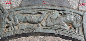
Then while taking these close ups, I saw that these weren't merely decorations but wind names. (all names are listed below.)

Some harken back to Greek or roman wind names.

Others like "Nor'easter" and "Trade"  seem to have a New England origin.

 
Plainly this needed more research.  At Wikipedia, I learned the following tidbits:   Linguistic anthropological studies show the majority of human languages(64%) have four cardinal directions; generally East-West equivalent indicating sun rise and sun set, and North-South equivalent for seasonal winds.

Aristotle referred to ten winds, North, South, and Pairings of East and West corresponding to various latitudes.

It was Timothenes of Rhodes who added to more points to make the classic 12 point compass rose.

These were interesting findings, and for awhile I thought this might be an augmentation of a classic compass rose.  But, after  looking up each name, I think this is merely an artistic decoration listing sixteen names of winds. 


The names from the Camden Compass, in case you're straining your eyes at the pictures are: 
NNW-N: Tramontana-  an Italian north wind
N-NNE: Boreas- Greek God of the North Wind
NNE-NE: Nor'easter
NE-ENE:  Trade
ENE-E: Foul
E-ESE: Eurus-  Greek God of the East Wind
ESE-SE: Tornado (from Spanish)
SE-SSE: Cyclone
SSE-S: Sirocco- a Greek wind from the Saraha
S-SSW: Auster - Roman God of the South Wind
SSW-SW:  Monsoon (from Arabic)
SW-WSW: Typhoon (from Persian)
WSW-W:  Fair
W-WNW:  Zephyrus- Greek God of the West Wind
WNW-NW:  Westerly
NW-NNW:  Mistral- a regional French wind
Referenced Wikipedia Articles:

Compass Rose :http://en.wikipedia.org/wiki/Compass_rose
Classical Compass Winds : http://en.wikipedia.org/wiki/Classical_compass_winds

(And, yes, we have been paddling this summer, but we're kind of in a rut where we paddle the same waters over and over.)