Thursday, September 30, 2010

Birch Stream – In Search of Color (Old Town, ME)

Basics: Launch Just before the Bridge on Route 116. (Exit 199 off I-95, south less than a mile on Route 16, left onto Rt 166, Southgate Rd) less than a mile to the launch. ) This launch is just a dirt ramp before the bridge abutment, there are no facilities, and limited parking. It sees regular use, both for those accessing Birch Stream and those accessing the Penobscot River. (This ramp is the same as the stop halfway around Orson Island) 6 miles, two hours. It’s definitely fall, and our records show that sometime in the next two weeks we’ll probably have our last ocean paddle. Not this week though, the weather has been too erratic: thunderstorms, rain or high wind have graced every day . Color is coming in gradually, some maples are at their peak, others just beginning to turn. Since red(swamp) maples are often the first to turn, we thought a paddle on a stream might present some beautiful colors. Plus a twisty stream is unlikely to be affected by all but the most powerful winds.

We’ve never paddled on Birch Stream before, and were a little nervous about how narrow it appears on the Delorme maps. When we paddled around Orson Island last weekend, the Penobscot River was frequently shallow enough that bottom showed. Would a tributary be better, or would we dead end at a beaver dam?

As it turns out, it was deeper than my paddle. The color was varied, some sections unchanged, others at peak, and even some bare branches.
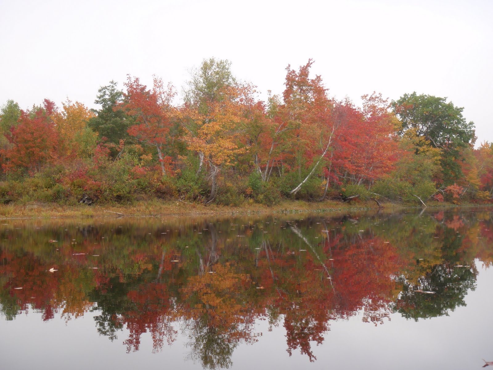
And the bright green of the rushes at the water’s edge made a great contrast.
The stream is home to many beavers, I counted six lodges on our way north.
There are side pockets along the stream but none of them went very deep, at least in the section we paddled. Note the many pale birch trunks.
I like this red maple because though it has barely changed, some leaves are completely red and others totally yellow. We didn’t see much wildlife, a heron, some cormorants and ducks, a few kingfishers. And this poor frog, hoping for enough sunlight to escape the many frog loving predators. We turned around shortly after passing under I-95, one bridge of the highway is new, the other much older. We did see a little sunlight on the way back – Yay!

Thursday, September 23, 2010

Belfast and the Passy (Maine)

Basics: Launch from the beach beside the town ramp. Generally parking is available, so long as no festivals are in town. Restrooms by the town ramp. 6 miles. Launch 11:10 AM, High 11:50, Finish 1 PM

Fall is in the air, the days are definitely colder, and unfortunately Mark is busier, so probably most of our paddles will be closer to home. But we still plan to get out and enjoy the water when we can.

This week’s trip was to Belfast Harbor, paddling the Passagassawakeag River. That’s a Native name, meaning place of the sturgeon. Coincidentally, the floor of the river is known for releasing bubbles of methane (though I’ve never seen this phenomena) leading some to shorten it to “Pass a Gas a.” Which is the wrong pronunciation; pa-SAH-ga-suh-WAH-keg if you’re interested. Those of us with less nimble lips call it simply the Passy.

This trip would follow our standard practice, paddling with the tide. We'd paddle up with the incoming tide as far as we could, then ride the current back. The wind from the northwest cooled us on the way upstream and accelerated our return.

These photos were leaving the harbor.

The three tiers are a float with cormorants, the walking bridge, and the Route 1 bridge.
There are so many beautiful old houses along the river, many with kayaks piled up near the shore.
Color was spotty along the trip, the maples and sumacs were beginning to turn. Hidden up on the telephone poles is an osprey nest. Can you find it?
Most colorful of all is poison ivy.
After we reached the point where our boats began to scrape on rocks we turned back, under the beautiful granite railroad bridge, now pinned together with steel.
We ducked into the northern most cove by this large boulder.
And spotted an eagle in a tree. I wasn’t going to take another blurry eagle picture until I saw it was really two. The larger bird is probably the female.
On down the river we went. Midway along the river narrows and wires stretch over it, providing a resting spot for many cormorants - watch for slice! One has given up on the wire and is resting on the mooring ball.
These seagulls were gathered under the Route 1 bridge. A graffiti artist had painted on a support: "Art or Crime?" Only in Belfast; affordable, liberal, funky and artistic. The photo shows Mark racing under a walking bridge, the Armistice Bridge. In the background is the skeleton of the building which was to become $600,000 condominiums on the harbor. It was a little too early for that, no condos sold, and the project remains unfinished. But someday soon I suspect Belfast will lose the affordable adjective.
I guess this dock is reserved for gulls.
The lead picture was taken in the summer. We could find only one on this visit. The exhibit is called the Long Breathe by Ryan Cowan, The Garden Muse.
In the background is the Cornish Pilot Gig, the Belle Fast. Come Boating sponsors community rows in the boats. Unfortunately they are often held early in the morning. But worth looking into if you are in the area.
Note how now that we’re finishing the sky is completely blue.
We made good time, Mark took the pictures heading upstream, so I only took a few close-ups coming back. That meant we could eat lunch at one of the many incredible restaurants in town!

Friday, September 17, 2010

Bartlett Island Maine – Decorating with Mussels


Basics: Ramp off Bartlett Island Road on Mount Desert Island. Parking limited, Portapottie. High 6AM, launch 10:30AM, finish 1:30PM 9.5 miles.

How crowded is Mount Desert Island? How popular is this area? Well, even before we arrived at the ramp there was a warning sign: “Caution dead end road, no turn around.” There is never much parking at the ramp, which is used by commercial fishermen, and may someday be offlimits to non residents (check the signs.)
As an alternative, if the area is jammed, a similar paddle can be had out of Seal Cove, just a few miles up route 102, and with much less stressful parking. Circumnavigation of Barlett may not be practical from there, but you can paddle by Hardwood and Moose, landing at Pretty Marsh, John, Folly or Bartlett Island.
But September is not as busy as August, so we thought we'd attempt it. We don't try paddles like this in the spring, which is when seals are pupping. Kayaks terrify harbor seals on ledges (in the water seals seem curious about kayaks.) Often seals are scared off ledges even before we are even close enough to see there are seals on ledges. If that happens in June, adult seals will abandon their babies, meaning sometimes a pup misses a feeding. Since pups only get fourteen nursings, missing just one feeding can be a problem. So we avoid any locations with seal ledges in the spring.
Bartlett Island is owned by the Rockefeller family, and the interior appears to be a delightful collection of homes, fields and forests. I imagine that half the houses on Bartlett belong to Rockerfellers and the other half are reserved for a skilled set grounds men and housekeepers. In this photo two trucks are pulling away after a boat pulled up at the dock, a red truck and a black truck.
Bartlett’s owners very kindly allow visitors to land on the shoreline. There are dozens of private beaches available.
We went around the island counterclockwise. On the east side are the narrows which can generate a significant current. Interestingly, we must have caught a back eddy, for though the tide was going out, the water was moving north. At the northern tip is this small island, the Hub, a Maine owned island. It is supposed to be a seal hang out, but we’ve never seen seals there.
MITA (Maine Island Trail) warns to avoid this area in the spring, and we do.
We stopped on a quiet beach halfway along the west side, with a friendly sign at its edge.

The tops of the beaches are littered with piles of storm strewn mussels. Since mussels keep their bold blue color, unlike many shells, they make a striking accent. A few more shots and the camera warned us that its battery was about to fail.

We decided to save the last few shots in case a seal or porpoise appeared.
After that we continued paddling south into the wind. Not a stiff wind, but continuous, with waves from the side, meaning there were a lot of side sweeps. As my hands grew tired, I needed to remind myself “Push, push”, reminding myself to propel my kayak by pushing the top part of my paddle forward with an open hand rather than by pulling the bottom side back through the water. Flexing my hand with each stroke keeps me from gripping the paddle too tightly.
In due time we made it to the south end, passing another pair of kayakers sitting on their “own” beach.
Then it was north again, weaving by two other MITA islands, Folly and John. Since no large sea life had presented itself, we took a few more shots of the area.
At the launch another kayak was heading out, and once again every parking space was filled.

Monday, September 13, 2010

Alamoosook Lake

Basics: Take Hatchery Road off Route 1 and 3 in East Orland, follow signs to Craig Brook Fisheries. Fair amount of parking, changing rooms, pit toilets, picnic tables by the beach. Flush toilets in Visitor’s Center.
As you pull into Craig Brook Hatchery, the first thing you notice is this grand sculpture.

Salmon have always been important in Maine. In the 1850’s 25,000 salmon a year were harvested from the Penobscot, but soon after the numbers began dropping. By 1871, the drop was significant enough that three states; Maine, Massachusetts and Connecticut, built the first salmon hatchery at Craig Brook. Unfortunately releasing a few fish, or even hundreds of thousands, couldn’t mitigate the effects of pollution, dams and over fishing. By 1947 no commercial fishing was allowed on the Penobscot and from 1957 to 1970 no salmon was taken by rod and reel. The Clean Water Act brought some recovery and by 1982 close to a 1,000 salmon were migrating up the river. But there the numbers stalled. This year, only 1,200 salmon were counted in the Penobscot; despite the efforts of the Hatchery which released 7.5 million salmon into seven Maine rivers. Maybe once more dams are removed and better fish ladders installed things will improve. In the meantime, here’s a reminder that there are many jobs that seem futile, but all you can do is keep trying and hope that eventually things will turn around.
We learned a lot about salmon in the free Visitor’s Center, which is open most days from 8AM to 4PM. There are posters, interactive displays, a film, young salmon in a simulated brook, and larger fish in tanks.

The Atlantic Salmon Museum, out back was not open, it was a small building with mostly a display of fishing gear.
The grounds of Craig Brook Fishery are what makes the location ideal for visits; nature trails, a pond and a lake to swim in, picnic areas, both near the parking and set off in secluded locations by the lake shore. It would be a great place to spend a hot summer day, paddling, swimming, relaxing.
We were just visiting for the afternoon though, touring the Visitor’s Center and paddling. Alamoosook Lake is lined with granite. Huge boulders decorate the shores and islands and small sharp pieces line the shores. Quartz can scratch glass, plastic boats stand no chance against it.

Not a good location to drive your kayak up onto shore. We launched by carrying the boats out to deeper water and getting in there.
We paddled out to Loon Island, where a tree was just starting to turn.
A cottage is hidden in this view, the owners request no trespassing. We wended our way through the other islands on the north side. Great Pond Mountain is in the background.

Then under this bridge, which I guess can take a car’s weight, and up Dead River.
The water level was too low to allow us access to Moosehorn stream.

It was a cool day, but eventually the sun peaked out, and this turtle climbed up to take advantage of the warmth. I don’t know how she got up on that branch.

When we made it back to Alamoosook the wind was blowing and there was some slight chop. It’s nice that it is finally cool enough that we can paddle without overheating.

Saturday, September 11, 2010

The canals of Bangor


Summary: 6 miles launch: beach at Hamlin Marina. Lots of parking, flush toilets. Dana’s Grill closed on Labor Day : (
Update:  Dana's Grill is now McLaughlin's and is open later in the season.  Bangor's kayak dock has moved to the south corner of the docks.
 
The Kenduskeag canal is one of the prettiest paddles in the Bangor area. You can launch your boat from the kayak dock on the waterfront. But, for a longer paddle, we launch from Hamlin Marina in Hampden, and ride the tide up and down.
This may not be the best paddle to do in the spring, when high water keeps the downstream currents in the Penobscot and Kenduskeag fairly high. It’s also not a paddle to do on a spring tide, especially if there’s been a lot of rain recently. A spring tide is one of the higher tides of the month which come right after a new or full moon. Spring tides can also be identified by time: high tides which occur between 11AM and 1:30PM. This is a picture of Hamlin Marina at a high spring tide. The normal edge is shown by the arrow at the grass.

The water height at the edge looks to be about 8 inches deep, Mark shows how high it is.

I guess it wouldn’t ruin a car, but I suggest unloading near the beach and moving the car back to the rear corner while you’re paddling. More importantly, some of the bridges on the canals are low, when water is flowing over the edge at Hamlin Marina it may be grazing the bottoms of those bridges, trapping you below them if you haven’t started up the Kenduskeag, or above them, if you’ve squeezed under the bridges on an incoming tide.
Another view of the marina.

The paddle to Bangor is enjoyable because of the variable terrain. Hamlin Marina is located by an old sawmill, the shore is built up of stacked logs. A beaver waits out the high tide on a lodge built in the cribwork.
Lots of flowers bloom along the shore.

At the first corner, eagles are frequently found. Once while paddling we surprised a poor eagle and it dropped its half eaten fish on our boat.
Then around the corner is Hughes gravel pit, whose shores seem to be a collection of scrap metal. Beyond that is a second marina, and informal RV park, and across the river the Cianbro plant in Brewer(also built by cribwork.)
Next are oil storage tanks, and sewage treatment plants, handily located on both sides of the river. But up ahead is the high 395 bridge, in elegant white cement.
Above the bridge is an asphalt cement factory, and then Bangor’s waterfront comes into view.
In the 1800’s thousands of schooners piled the Penobscot, landing in Bangor and leaving loaded with timber. By 1983 Bill Caldwell, author of Rivers of Fortune, claims there was no place to anchor a boat. He was riding on a Coast Guard ice breaker which wound up mooring on a pile of junk near a railroad track. Now there is a dock, divided between guest and summer slots.
Just beyond the docks is the opening to the Kenduskeag. The Kenduskeag Stream was over 400 feet wide when settlers first came to the area. By the 1800’s businesses had narrowed the stream to 250 feet. Warren Manning, a Boston landscaper, thought to install the Norembega Mall after the Great Bangor Fire in 1911, removing dilapidated building and cribwork, and replacing them with canals reminiscent of Venice.
The first bridge is a railroad bridge, then come three pedestrian bridges, followed by two street bridges, while you paddle beside parking lots, banks and the new courthouse. The second street bridge, State Street Bridge plays an infamous role in Bangor history, since it is the bridge from which Charles Howard, an openly gay man, was thrown to his death in 1984. There is now a garden on the south side of the bridge dedicated to his memory.
Above State Street bridge the buildings shift to older buildings built in the early 1900’s. And beneath the bridges, pigeons lurk and unidentified pipes carry who knows what. The canal divides about the Norumbega Mall, the north side has pedestrian bridges going to Norumbega Hall, which currently houses the University of Maine Art Museum.
Central Street is the next road bridge. Notice how the Bangor Savings Building echos the curves of the Franklin Street Bridge.
After the Franklin Street Bridge the canals shift to being a river, overlooked by Condos and a streamside path. Further up, you’ll pass under a pedestrian bridge built on the base of the old Morse Covered Bridge.
On some tides you can paddle up under Valley Avenue Bridge, and after that rocks in tend to make the stream impassable. Looks to be as far as we can go!
Time to turn around and head downstream.
Norembega Mall is also an enjoyable stroll, here are some shots from an evening stroll, note how low the canal is.
And the fine brickwork on the older buildings.
Finally, these footsteps appeared by the edge of the canal just below the State Street Bridge. Who has read Stephen King’s It?