Tuesday, May 31, 2011

Paddle to the Sea Part 3: Verona to Fort Point Maine

Basics: Verona Island landing: Plenty of parking, no facilities (public toilets are available along the harbor in nearby Bucksport)


Fort Point State Park: Stockton Springs $2 per person entrance fees. Pit Toilets. Not technically a launch site and a rather long haul to the water.

High Tide: 10AM. Launch 12:20PM, finish 2:04PM, 8 miles.

What a difference a week makes! Our third leg would be on a bright day with temperatures in the 80’s. Rather than barely seeing the far side of the river, we could easily see four miles ahead. Rather than cringing as we waded in to launch, we welcomed the cooling powers of 50 degree water. This leg would take us from Verona Island to Fort Point in Stockton Springs.

This is the trip I looked forward to the most. I’ve been along Verona Island many times, but generally at peak or ebb tides. Today we’d be riding at mid tide, flying through the Penobscot Narrows. For as I taught Webelos again and again, the Bernoulli Principle states that water does not compress, so where it narrows it flows faster.

It is also one of the most scenic areas, with Fort Knox, the bridges, and Sandy Point, as well as the high banks which caused the Penobscot to once be known as the “Rhine of America.”
We started at the Verona Ramp in a confused back eddy created near the island. A pleasant whiff of crushed wood fiber from the Verso plant confirmed that the wind was from the north. Cormorants and seagulls decorated nearby rocks, but not a single buzzard was in sight.

Soon we were in the downstream current, which didn’t seem too bad by the bridges, but was easily dragging this buoy under.
New to the shore was this cross.
Old to the shore were the bright rocks and high walls. Overhead a flock of young ring bills passed by, one after another, their brownish bodies dark against the sky.

We clung close to Stockton Springs shore. I couldn’t help but look longingly to Odom Ledge and what looked to be several seals there. But pupping season is near, if it’s not already here. Seal pups nurse as few as 14 times, and cannot afford to miss a feeding. Since seals are often nervous in the presence of kayaks we wanted to stay at least a quarter of a mile away.

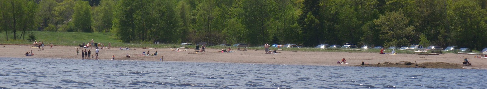
In place of observing seals, I watched the crowds at the beach. What a rarity, to have such a warm Memorial Day! Sandy Point is a free beach located in Stockton Springs, and a sandy beach to boot. Since it’s in a cove, it does not have the strong currents we enjoyed further off shore. There is plenty of parking, but no facilities.
Just below the beach was an abandoned set of pilings which have become a nesting colony for cormorants. My guide books describe cormorant nests as large and bulky, but they seem pretty basic compared to the more ostentatious nests of eagles and osprey.
Next were the beautiful shore houses of Sandy Point. We pulled out of the current to inspect this solidly constructed boat house, and admire the other houses.
A tall dune marks Sandy Point, atop the dune was a gazebo belonging to Hersey Retreat. That dune is a glacial esker, which has been eroding away, creating the sandy beach along the shore.

Beyond Sandy Point was a deep cove. We intended to follow along the cove shore, but we could hear a seal barking in caution. I didn’t see any ledges on the chart, and the shoreline seemed to be mostly marsh, but the sounds of distress were obvious. Rather than disturb a seal we opted to paddle straight to Fort Point. And what a great ride it was, with the wind to our backs and waves perfectly designed to aid us without requiring too much attention on our part.

At Fort Point folks were also out in abundance. Swimming is not allowed at Fort Point because of the strong currents. We rode those current out and took a few pictures of the lighthouse, before returning upstream to the dock.

It looked like it would be a challenge getting our kayaks to the top of the ramp, so instead we hauled them up the bank, which was also not an easy task.
A final picture of a sailboat at the base of Verona Island

Wednesday, May 25, 2011

Paddle to the Sea, Part 2 Hampden to Bucksport Maine

High Noon, launch 12:15, finish 3PM 10-11 miles.

On the plus side, it was ten degrees warmer than on our previous trip. And there was not as much wind, though what wind there was came from the east, rather than helping to push us from the rear. But it was the need to continually run the wipers as we positioned a car on Verona Island which made me think this might be a less comfortable run. However Mark wasn’t showing any inclination to back out, so neither would I. It’s been rainy/misty/showering for almost two weeks straight, though it might dissuade us from driving a long distance to paddle, by now we would rather get wet than miss another day.

So shortly after noon we hiked back down to our landing to continue our journey down river. (Again those without a house in Hampden/Orrington might try the Hampden launch or the Orrington Launch )
At the Winterport line the Penobscot makes a sharp bend, and mist had collected along the Winterport shore; a mist full of the scent of the river, dirt from the hillside, pine needles and grasses. There was another sharp bend a mile later, directing us south again.
We passed by the gentle hills, and a marina, and soon a second marina came into view.
 Winterport; where in fine tradition, many of the old sea captains homes faced the river.

The Marina in central Winterport.
Across the river, as we rounded Drachm Point, the Penobscot Narrows Bridge just came into view, and the river widened, the air was now scented with salt.  This was also the section where we spotted our first (and only) seal of the trip.
Next we passed by the mouth of the Marsh river, Mt Waldo is in the background. Right about here salt water begins to overwhelm the fresh and seaweed begins to appear on shore.
These cormorants were gathered on an old pier near Luce Cove.
On we travelled, passing by the buoy formerly known as buoy 39
And coming up on a row of cliffs at Indian Point just above Bucksport.

Here the scent changed again, smelling distinctly of balsam, before we rounded the corner. As Verso came into sight, the scent was more general ground wood, not the distinctive Christmas tinge it had earlier. And the air was warm, which I mistakenly took to be a south wind, until we passed the plant and the air temperature dropped several degrees and once more was salty. I guess the steam from the plant had just been blowing up the river.
A classic Fort Knox and bridge  view.
We were in Bucksport harbor, with its welcoming waterfront; a gazebo, plenty of parking, benches, tables, toilets and a walkway.
A short while later we’d stopped at the Verona Island landing, stage two done!
Plenty of seaweed at the landing, so it is definitely salt water.
An alternative stopping point is Marsh River Landing in Frankfort

Friday, May 20, 2011

Paddle to the Sea

Paddle to the Sea by Holling C. Holling was one of my husband’s favorite books growing up. It tells the story of a small carved Indian in a canoe who makes his way through the Great Lakes to the Atlantic Ocean.

Our journey would be smaller than that, tracing the Penobscot from the head of the tide to Penobscot Bay. Like many trips, it was envisioned on a dreary winter day as a great activity for early spring, four quick day trips leading down the river. Unfortunately as spring wore on it became more and more obvious that we weren’t going to get four days in a row to paddle, instead, we spread the trips out. So, if in our photos you see the leaves get bigger and greener (and eventually turn crimson), it’s not due to the increasing salinity, but rather because it is getting later and later in the season.

Trip 1: Penobscot Salmon Club to our landing in Hampden. 8-9 miles High 11AM, launch 11:30, finish 1:15

The Penobscot Salmon Club allows hand carried boats to be launched there, just below Treats Falls. An alternative launch site, if that location is closed or the water levels unsafe, is beside the Sea Dog in Bangor. There is an outhouse on site and plenty of parking.

We launched on a gray day with a brisk wind from the north. Mark and I had both worn extra clothes in the car, thinking we would shed them before paddling but the chill wind changed our minds. The icy water raced by my feet as I readied my boat to launch from the small beach. I’d been paddling without waterproof shoes for weeks by our house, but this swift moving water reminded me how cold the river remained.

Treats Falls, and Bangor waterworks are shown below. Be sure also to check out the photos in Caution
                     

In no time we were off, racing by the amalgamation of buildings which is Eastern Maine Medical Center. There is an old section
And newer sections


Meanwhile in the river, stealth buoys poked above the water before bowing again to the unceasing force of the currents.
We rode by the railroad bridge, whose center abutment had an iron bar to protect it.
Meanwhile, at the mouth of the Kenduskeag a train crossed a different bridge.
Nearby Public Works was wrestling the Bangor docks into place.
South of the 395 bridge were some of the many young cormorants who will spend breeding season in the Penobscot River, out of the way of the older birds.
Along the shore lay the remnants of some old industries

Nearly hidden (in that photo) is a newer industry, Cianbro.  Across the river in Hampden, Hughes Brothers always reminds me of a model railroad set
With the recent rains, all the streams were running high, so the river was bounded by waterfalls.
Not that the extra water always led to pretty results, the Penobscot is bordered by unstable bluffs of rock and clay. Many trees were passed were leaning far over, and soon would tumble.
Once we passed into Hampden/Orrington, most of the houses were built further back from the river, allowing more natural views.
It was a great ride, when you look at the time recall, much of trip I was taking pictures, so the wind and current gave us a real boost. If you don’t happen to have a house in Orrington or Hampden other locations to pull out are the Hampden Boat Launch (about 4 miles down) or the Orrington Boat Launch (about 11 miles down)(links)

The Penobscot River Keepers  also do a Paddle to the Sea type events every spring, sharing different sections of the river with students hoping to connect them to the rich heritage the river holds.


Sunday, May 15, 2011

Phillips Lake, Dedham Maine


Phillips Lake with Bald Mountain in the background
Basics: Access from Pearl Point Rd (off Poplar Rd) Narrow Gravel Ramp, not much parking. No facilities.

Phillips Lake is lovely, deep and clear, decorated with granite boulders, surrounded by hills, sprinkled with islands. Access is limited.  The launch is a narrow strip wedged between a private beach and Camp Capella, parking is limited to some wide spots at the top of the ramp and along the camp road. So, it’s not a place I would recommend visiting on a hot summer weekend.
The launch in use, the rock to the right marks one boundary
We were there on the one bright day of the week, the one day above 50 degrees, the one day without rain and the many black flies who’ve been lurking in shelter all week building up an increasing hunger were there too. Generally, I expect black flies to be bad at a launch and often carry a bug net to use while I strap down boats. But usually on the water, they tend to disperse. These persistent bugs were always with us. I hear that black flies can’t fly over 1 mph, but I suspect they may be faster, for whenever the wind died, there they were. Not that they were terrible, but they were always nearby, ready to crawl on my face.

Six of the islands on Phillips Lake (Shelter, Patmos, Treasure, Fortune, Mystery, Moccasin) allow access through an easement by Great Pond Mountain Trust and available for careful day use (no fires). Sadly, I’ve yet to find a map naming the islands, but one has a sign posted on it clearly marking it for day use. Not that it mattered to us, because I was not going to voluntarily stop to feed the natives.
Instead we wove between the islands, admiring a little Christmas tree island.

And the ice carved  rocks.
We cruised the shore admiring the houses, especially this classic cottage, built right on a rock by the shore.
As the wind died off for longer and longer periods, we decided to return to the launch and practice efficient boat loading.

Black flies are considered “the defenders of the wilderness” by the Maine Black Fly Breeders Association. And it is true that they do encourage a certain efficiency to outdoor usage. As I looked at various black fly sites, I was reminded that black flies prefer dark colors and are attracted to perfumes. They mainly stick to the head, so a hat is advised (and sometimes a bug net). They are rarely active below 50 degrees and a mere 4-7 dry hot days usually eliminate the scourge. Much like rain, they are rarely as unpleasant to endure as missing out on a day of paddling. And as a bonus, the male black fly is thought to be a major pollinator of blueberries, so they aren’t pure evil.

These last little foxes are from an evening paddle (sans flies) along the Penobscot. I’m not sure if there den is in the banks or that’s just where they were hiding while momma was out hunting.

Sunday, May 8, 2011

Reporting Dead Sea Mammals

I’m not quite sure what happened, but somehow we’ve become mired in home repair and improvement projects, most of our paddling trips have been short and on the river. But not necessarily uneventful.

The top photo shows a barge starting on its journey north to deliver a module to a nickel processing plant in Newfoundland. We spotted that shortly after we discovered a small long-dead harbor porpoise. (I’ll spare you those photos.)

Once home I reported the porpoise to the Maine Marine Animal Reporting Hotline(1-800-532-9551), which requests sightings of any live or dead sea mammal. 1-800-532-9551 gives a series of automated prompts. The first set was easy: “Press ‘1’ to report a seal, Press ‘2’ to report a turtle…” The next set not so; it gave location ranges and numbers for live and stranded animals. Eventually I wound up leaving a message on an answering machine at the College of the Atlantic. To be fair, that number also gave me the option of contacting a cell phone fort emergencies. I felt there may be some interest in noting the dead mammal, but it was not worth disturbing someone on Easter.
The next day as we waited for updates on our car repair, delivery information on our flooring and a call back from a radon mitigation specialist I had a call from the NOAA representative at College of the Atlantic. She was interested in seeing the porpoise. First I ran down a third of the way down our hill with a spotting scope to determine if the porpoise was still there. It was and a few buzzards had joined it. (I suspect the buzzards had visited many times prior.) I called NOAA back with the information I had; she then requested driving instructions. That was more challenging. For while the porpoise was within sighting distance, it was over 20 miles by road from our house, and I’m not sure the access roads shown on Google Earth were open for public use. Unfortunately COA’s boat was not currently in the water. I was planning on sending her my photos so she could assess if a trip would be beneficial when Mark noted a NOAA fisheries boat on the far side of the river.
It was a salmon studies group, coincidentally setting up an experiment. Mark raced all the way down the hill and managed to waive them down. Various phone numbers were exchanged and the NOAA salmon folk agreed to add examining the deceased porpoise to their activities.
One last photo just for fun; from a scant four days earlier before the porpoise sighting, Mark paddles into an inlet filled with snow.
Now the blackflies are out in nose filling force, but soon they’ll be gone, and they do give us a reason to look forward to windy days. Meanwhile, we've got transportation, our shed is filled with wood, the radon mitigated and enough flooring installed to realize we'll need to order more. But hopefully we'll take some road trips soon...