Sunday, August 31, 2014

Ambajejus - Beautiful and Fascinating


   We were sitting in a motel room in Millinocket after a failed expedition to spot moose.  I flipped back and forth between some pages in my Delorme map book looking for a place to paddle.  Did we want to go up by Baxter State Park?  Head along the Golden Road ?  Drive along the East Branch of the Penobscot River?  Stick close to Millinocket?   My eyes scanned the map and noticed a scenic attraction symbol by a lake and the text "Ambajejus Boom House." (Note:  This was in my 2011 DeLorme, which I keep in the car; it was not in my 2004 version which I keep at home.)
I did a quick Google search:

"The Ambajejus Boom House River Driving Museum is housed in a 1906 vintage 1 ½ story building at the edge of Ambajejus Lake.  It was used to house river drivers who worked on the rivers and lakes bringing logs from the forests to the paper mill and has been restored to its original state.  It is comprised of a kitchen, parlor, dining area and bunkrooms and contains a vast collection of tools, equipment, photographs and hands-on displays representing the way life was during the years it was occupied by “Booming Out” crews.  Henry David Thoreau wrote of this spot at the mouth of the West Branch of the Penobscot River in his 1857 Trip Up River to Climb Katahdin.
The Boom House can be visited by way of boat or float plane.  The fee for this journey back in time is a moderate donation toward the upkeep of the museum."  
   (from Katahdin Area Chamber of Commerce website)

   Now, I don't often go to lumbering museums, but a museum that I needed to boat to - how exclusive!  Looking at the map, the museum was about 3 miles from the launch across a large lake attached to an even larger lake.  Ambajesus (which may mean "eddy"  in Abenaki) is a part of the "Pemadumcook Chain of Lakes", which itself is a part of the West Penobscot River.   The Pemandumcook Chain of Lakes includes Ambajejus, Elbow, North Twin, Pemadumcook, and South Twin. Each is a large lake; altogether they are the fifth largest lake in Maine.  Generally I don't find large lakes fun to kayak.  Still, a museum on an island, in the north woods of Maine....

   The next morning what was supposed to be a quick scout for moose somehow became multiple hikes, multiple drives and still no moose.
Sandy Stream Pond, gorgeous, but no moose
   Near lunchtime we were sitting by Upper Togue Pond. (Delorme page 51), tired of hiking and discouraged by how much time we'd spent on a fruitless quest.  Upper Togue Pond is a small multi-lobed pond.  We watched some loons take off in flight and debated, kayaking here and just poking into the many coves.   It was tempting, but on Ambajejus we'd have a goal....

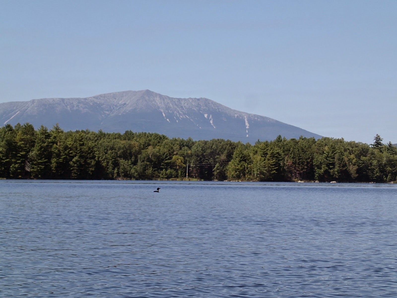
   So we drove back to the lake on Delorme page 43, to the launch in Spencer Cover.  Spencer Cove was lovely, spotted with islands, mountains ahead, mountains to the north, bounded by well-maintained houses.
   Our first surprise came as we rounded into Ambajesus Lake, and we saw what looked like a large sandstone formation.

   But we soon realized it was sawdust, left from a mill that was there 80 years ago.  Several times we'd driven by Saw Pile Rd.  Somehow I never imagined it was a huge saw pile by a lake.  
   Since its formation, it has been carved by the wind and made into homes for cliff swallows.

   A new sight for me, but as a child Mark once lived next door to a saw mill. He tells of fun times sledding down sawdust piles and building "forts" dug into the soft, fragrant material.

   My next surprise was a loon snorkeling.  It swam along at the surface with only his head below water.  I guess that's a more efficient way to look for fish, and is probably very common, but I hadn't seen it before.

   Soon it was time to cross to the Boom House - and here it is:

   And this is the sign on it.

   It's probably a pretty neat place, the rings placed on the nearby rocks are certainly huge.

  So you might think that not seeing a moose, and not having the museum be open I would have been totally depressed.   I was sad that this quixotic museum might have run into a problem beyond what voluntary contributions could cover.  But I was not upset that I'd spent the time paddling on Ambajesus.  After all, I'd seen two magical sights: the snorkeling loon and the saw pile.  The lake was lovely, the day perfect for paddling.  And when I'm looking for moose I have the nagging suspicion that I'm doing it wrong.  While I'm gazing out at Compass Pond, (where I've seen moose twice before) the moose are wandering through Pickerel Cove at Millinocket Lake; when I'm up by Sandy Stream Pond the moose have meandered over to Abol Pond; when I'm up in Millinocket moose are probably dancing on the sidewalks in Bangor.
Just a few minutes late to see this moose
 When the museum isn't open, it's not like it's branch has opened in downtown Millinocket.  The museum is still there.  Besides, with views like this throughout the paddle, how can you complain? 

More about the boom house.
Ambejejus Boom House pictures at Maine Memory Net
An interview with Chuck Harris, who restored the Boomhouse
Katahdin Area Chamber of Commerce information on the Boomhouse
Digitized Article:  Making Paper in the North Woods
Penobscot River Corridor Camp sites

Summary:  About a seven mile trip, lots of parking, paved ramp, no facilities.


Sunday, August 24, 2014

Bois Bubert and a distant house.


 Bois Bubert is mostly owned by the Maine Coastal Islands National Wildlife Refuge.  It's a big island, over 1,000 acres, close to shore, and we hoped circumnavigation would make for an interesting trip.

  We began from the Steuben Town Launch just after 9AM,  just before high tide.  We decided to follow the island counterclockwise, guessing tidal effect was more keenly felt in the narrower west side waters.
  There are privately owned houses on Bois Bubert, mostly directly across from the Steuben landing.    By the houses  fields run down to the beach.
   The cottages were soon passed, and gently sloping grass gave way to rock.   We enjoyed the dramatic colors of the island, intrusions of various shades of gray amidst the pink granite.
    Some seals were hanging out off shore. The young seal seemed to be particularly enjoying the day.
  The south end of the island is more prone to lively waters.  Though things were pretty calm as we paddled through, we did need to keep an eye out for ledges.

   We took a break in Seal Cove, by the available camping area (permission needed ahead of time from the USF&W.)  We didn't inspect the camp area, spending our time admiring the variety of granite and other rocks on the beach.

  Off in the distance the dark forbidding cliffs of Jordan's Delight  towered above the water.  On the high island top was a house, which appeared to be the perfect house to witness the power of winter storms, or avoid the zombie apocalypse. 
Jordan's Delight as seen from Seal Cove on Bois Bubert, House is to the right.
  It was an intriguing house, and once we got home we were able to research it.   In 1994, a house described as a two story, "grand" mansion of 3,000 square feet, was built high on the cliffs of Jordan's Delight.   Some stories  note that the house was built in nesting season, (as if there might be a different season when house building could occur on an island in Maine), others just note the inappropriateness of the house.  And perhaps the owner came to realize the inappropriateness and impracticality as well, because in 2000 the house and island was put up for sale.  Maine Coastal Heritage Trust was able to find a donor to help purchase the island.  In a story which received much publicity,  (some examples:  Bangor Daily News, Living on Earth,  and Gulf of Maine Times) the house was removed.  Less frequently mentioned was a small house which, along with a few acres,  the donor would retain.  Maine Coastal Heritage transferred the rest of the island to the National Wildlife Refuge in 2007.  Jordan's Delight now serves as a prime nesting areas for one of my favorite Alcids, the black guillemot.

   So the remaining structure must be the smaller house, also two stories, available for the owner's use outside bird nesting time.  It still must have an amazing view, but it seems to be a bit wanting in maintenance (sorry for the poor definition - photo taken with our new high-zoom camera from almost 2 miles away)...

  Leaving the mysteries of Jordan's Delight behind, we continued up the east shore of Bois Bubert, admiring this fascinating square-rocked beach, which we need to explore some day.
   And there are a series of small islands between Bois Bubert and Jordan's Delight which should be seen as well.
Mark by Douglas island
 The northern shore of Bois Bubert has wave created rock piles so sharp edged, it looks like someone piled them by hand.
  This yellow legs is one of many birds in the area.

  All in all it was a good mix of wildlife, rocks and ocean, and it was certainly helpful to be able land at pretty much any beach we passed.  We wouldn't have been able to capture the seal pictures if we hadn't been on shore.  We hadn't been here before, but we'll go back to see the rest of the bay.

Details:  Launch Steuben Town Landing, no parking on site, limited parking is about a quarter mile away at the Pigeon Hill Preserve.  No facilities - either location.  Camping is allowed on Bois Bubert with permission from USF&W, day use allowed without permission. (NWR areas only)  Launch 9:10AM, high about 9:30AM.  Finish 12:30, 8.8 miles including a pass  between the Douglas Islands, two stops.

Tuesday, August 19, 2014

Mathew Cove, Moosehead Lake


Driving into the area, over Indian Hill
Seeking a change of scenery we headed inland to Maine's largest lake, Moosehead.  It's forty miles long by ten miles wide, with a maximum depth of 246 feet.  We could spend weeks paddling its shores.  But we were just looking for a day's adventure.
Lazy Tom Bog from the road
We began our morning with a Moose-sighting hunt.  We started at the Department of Transportation building in Shirley, then drove through Lily Bay and Kokadjo without success.  At Lazy Tom Bog, we hoped into our kayaks and headed upstream.  In less than half a mile we saw a nice male moose, his still growing antlers covered in soft velvet.  Unfortunately, we missed the picture, but we had the experience.
Probably the moose is just to the left here, but when we turn and see him, off he'll run.
  We continued up Lazy Tom to a beaver dam, and took that as time to head back to explore Greenville.

Some other paddlers exploring just off the Greenville Jct Launch
  There are launch in Greenville and Greenville Junction which we were considering.  Greenville Jct. seemed to have a better set up; more parking, changing rooms and bathrooms. (Always a plus)   But both meant exploring a shore line of vacation homes and avoiding boats, seaplanes and everything else.

   We spotted the lovely Katahdin at its dock in Greenville.  It's 100 years old this year, and had a birthday celebration recently.  I include the link because it tells the tale of its distinguished work career. 
Since neither of south end launches had much paddling appeal to us on this particular day, we went to Lily Bay State Park and launched from Rowell Cove popping in to explore Mathews Cove, especially the shallow island filled area.
On Moosehead Lake by Sugar Island.  I can just see a distant Mt Kineo.
In the shallows of Mathews Bay
Mark liked the tiny islands, with just a few trees.

I admired the way a single tree stump could become a home for an entire community.
Nature does some impressive design work.
A second angle on the same roots, giving them a more "circle of life" appearance.
 It was just a couple short paddles, but a nice accent to a fun day of exploring!

Summary:  Lazy Tom Bog (Stream), north of Kokadjo:  Launch is a turn off the road just after the bridge.  I'm not sure teh road has a name, but it's in the DeLorme.  No facilities.   Maybe a mile to the Beaver Dam, Google Earth shows the stream narrows considerably from there.
Greenville Jct Launch.  lots of parking, seperate long term lot nearby.  Bathroom open 7AM-9PM.  Paved. beach and playground.
Lily Bay State Park, Beaver Cove, fee to enter, two launches each with docks and ramps.  Pit toilets by launch, it looks like flush toilets by the beach.  Beach, camping if you make reservations far enough ahead. 

Sunday, August 17, 2014

Belfast Harborfest - Cardboard Boat Race

This weekend was Belfast Harborfest- which included a Pilot Gig Rigatta, a small boat display, the boat building challenge, (where teams were given three hours to build a boat), a 5K Road Race, and much more.  Sunday was the cardboard boat race. 
   There were two main styles of boats, canoe-like and row-boat like.   The full rules are here, but a summary we were given was:  Cardboard with water soluble glue and water soluble paint.  Duct tape is allowed only at the seams.
  Style mattered, as there was a People's Choice Award.  Three boats were decorated in Viking style.  But heart mattered too.  Apparently the Rollie's Bar and Grill teams began work at 9AM and were able to make the 10:00AM start with two entries!
   It was a moist morning, those who brought tarps used them frequently.  After the boat parade the vessels rested on the beach.  Most of the first heats were two boat races; one was three.  Waiting contestants lifted their boats, rested them on paddles, or in some cases cardboard.  There were three Viking themed boats, this shows two- Angry Dragon and Valhalla.  In front is an international competitor- the Rondy-Turcotte family from Quebec, Canada.
 Like a Rock 2.0  the Dutch Chevrolet entry paddled with confidence.  Their heat was against Rollie Red, which barely left the starting point.
  But Rollie Pink did better; here they are battling against Coburn Shoes' Boat Shoe.
    Unfortunately, the unfinished boat did not hold up.  But the race was held in shallow water at low tide, so after the back paddler rolled out, he was able to push his boat to shore.
  The Waldo County YMCA set the fastest time in any heat, finishing the course in just under 2 minutes.
   Size matters, originally  Barque Ahoy, built by the Penobscot Marine Museum was going to be paddled by three people.  But Archimede's displacement theories held, and after a quick sinking, a second attempt was made with just one paddler.  (She has a life jacket under her shirt)
   Yellow Submarine, sponsored by Searsport High was built at a Penobscot Marine Museum Cardboard Boat Camp in June.  It won its heat and placed fourth overall.
  The Norseman Nightmare, by the Vanderhoof Family, also suffered a quick roll at the start.  But they quickly got back into the race.
  Perhaps because the boats were fading fast, one final heat was done for the winners of all previous races.  There had been six heats, but only four opted to participate in the final race.  
   The Angry Dragon wound up with the overall prize.   (This picture is from their first heat.)

Wednesday, August 13, 2014

August 11, Hermon, Maine


   What is this floating down the Souadabscook Stream?


   Is it from this branch above?   Surely this must be an aberration.


   But here's another tree on shore.


    And a whole series of tree  along the shore of Hermon Pond.  
    Like it or not, fall is arriving in Maine.