Saturday, June 30, 2012

The Island Maneskootuk, Rangely Lake Maine


      How many lake islands in Maine have had a best-seller written about them?  One, as far as I know.

     Maneskootuk Island, or Doctor’s Island in Rangeley Lake, Maine.  The book is The Islanders by Elizabeth 
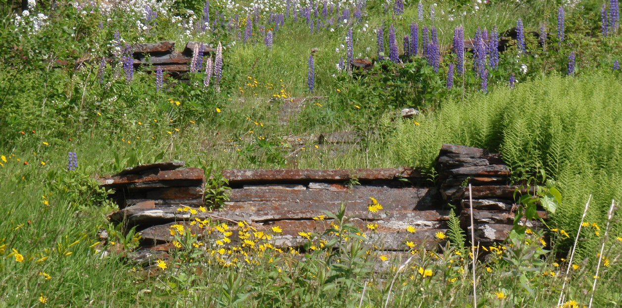
Foster and tells the story of the house her grandfather, Frederick Dickson built on the island, their many summers there and especially of the garden her grandfather built and lovingly tended.

   Our paddling companion had read that book and a follow up book by Carolyn Scofield.   A gardener herself, she wanted to see the remnants of the massive garden.
Approaching Maneskootuk
        And so we set off from the Rangeley boat launch in our trio of boats: a Wilderness Systems Zephyr, Current Designs Sirocco, and Old Town Tandem Otter.  We started early in the morning, to avoid wind driven waves that can build during the day.

                The Otter moved smoothly, although we were not ideally positioned in the boat.  The front seat serves as a brace for the back seat.  Unfortunately, the back seat did not move easily, so we were further back than was ideal for boat trim.  However, we were well matched paddlers, and despite the Otter’s 29” beam we had no trouble setting a good pace. 

                It helped that on the way our gardening companion entertained us with tales of the island and the steamboat which used to carry visitors out.
A bright log cottage
        Maneskootuk is a private island, festooned with No Trespassing signs and decorated with assorted houses, cottages and sculpture.  The original grand house burned in 1939.  We worked our way about the island until at last, on the southern slope we were rewarded with views of the garden remnants in eight glorious terraces.


            Maneskootuk is an Abnaki phrase, picked out by Frederick Dickson to describe the island.  It means “Place of the Big Trout”.  And, in case you’re wondering, he was not a doctor, but a lawyer.  Doctor’s Island reflects a later use of the island, as camps (cottages) only doctors were permitted to rent. 
Amazing mountains serve as a backdrop to the lake
                The Islanders is available from many sources.  However, the follow up book,  The Island Maneskootuk by Carolyn Scofield, telling about later owners of the island, is harder to find.  One source is the Ecopelagicon Nature Store in Rangeley. (Ecopelagicon also rents kayaks, sells gear and arranges shuttles.)   
Our intrepid explorers heading back to Rangeley
Launch:  Rangeley Town Park.  No charge, restrooms open by 8AM.  4 miles to go out, around the island and back.  The Old Town Otter worked well, though I doubt we would have been happy had waves been slopping into the large cockpit.

Saturday, June 23, 2012

'Sup?


   I happened on these cheery little fellows in the Museum of New Brunswick, and they made me wonder..."What would the original Bangor Tigers* think of SUP(Stand Up Paddling)?"

*Penobscot River Log Drivers were often referred to as Bangor Tigers, especially when headed out to more distant drives.  A few tales of their esteemed skills:
Bangor Log Driver Navigates NYC's Hells Gate with Fanfare.
Log Drive on the Connecticut
 
     Since the small models were from New Brunswick, they probably reflect St. John log drivers, but they look ready to SUP.  This statue by Charles Eugene Tefft depicts Penobscot River Drivers (and serves as a reminder of cooler days.)

Thursday, June 14, 2012

When was the last time you used your radio?

Boats are hidden in spray
       You know what's not a good feeling?  Sitting on the New Hampshire side of Portsmouth Harbor, with your car on the Maine side and watching two Coast Guard boats practicing high speed jousting - or maybe interception runs

  They were right where we planned to cross.  So what to do??  "You're going to have to call them on the radio."  Mark said.

  I keep my VHF radio tethered in my pfd pocket.  Mark's radio, which is older and larger, is in his day hatch.   My radio has a good charge, it was fully charged before the trip.  On the back of my radio are "mayday" instructions, but they've kind of worn.  This isn't a "mayday" issue, so what is it?  "Pan, Pan?"  "Security?"

   What I remember best from VHF rules is never to actually use it in play or practice; we always practice with the radio off.  I also don't want to interrupt official Coast Guard training if I don't have to.  So I turn my radio on to channel 16 while we do some more sightseeing.  No message from the Coast Guard, and no pause in the skirmishes either.  Actually, it seems like they're using more of the harbor than they were at first; so I'll have to call.  We're paddling back to the Fort Point to be in position for the crossing, when one boat takes notice of us and comes by to ask if we're looking to cross.  We confirm that and book across.

   So one more thing to add to our Spring list; in addition to checking the emergency gear, charging the radio, and trying an emergency call also think about non emegency uses of the radio.

     Crossing protocol  seems to vary slightly from site to site, but MITA’s guidance is to use VHF 16, press the microphone button and call “Security, Security, Security this is 2 kayaks in Portsmouth Harbor crossing from Fort Point NH to Fishing Island, ME, course is 45 degrees, speed is 3 knots, any traffic in the area please respond.”  If I didn't hear back specifically from the Coast Guard, I'd try again.

And some more links to VHF radio guidance:

Paddling Light suggests laminating a card to use for practice.  I recommend, if you don't use a radio regularly, use a small font, list not only emergency but crossing instructions, and tape it to your radio.

Thursday, June 7, 2012

Kittery/Portsmouth harbor


    It was a gray damp day when we made our fifth and final paddle on our quick road trip. Kittery: we'd be paddling at the start of Maine.  Fun fact - Kittery is just about half the distance from Mystic CT to Bangor ME.

     Kittery’s town ramp at Pepperell Cove has limited pier parking.  Dorcas Miller’s Kayaking the Maine Coast provides several alternative parking arrangements, but on a rainy day in May, we parked on the pier directly across from the ramp.  There at the ramp was a sign with manila envelopes listing the launch fees; $5/vessel emphasizing that all boaters must pay.  Reluctantly, I filled out the lines and brought the envelope to the Harbormaster’s Office.  I felt slightly better when the Harbormaster pulled up as I deposited the envelope in his door.

     The Piscataqua River and Portsmouth Harbor are known for strong currents.  We thought launching near low tide would minimize that problem.  We had planned an earlier launch, but morning fog delayed us, and as a result we launched at dead low.  It was a muddy slog to the water.   
    Portsmouth Harbor is crowded with forts and lighthouses.  We were starting off beside one, Fort McClary.  Fort McClary features a blockhouse style fort.  Forts have been manned at that location in five different wars.
Fort McClary
         Fort Foster was just a short hop away. It appeared to be a World War II era fort; more history for Fort Foster is listed here.  

        Just off shore from Fort Foster was Wood Island and the old Portsmouth Harbor Lifesaving Station.  A group has been formed to try and preserve the building.  Our cursory inspection indicated they had quite a challenge ahead of them.
        Whaleback Light was our next destination, a lovely lighthouse and home to several eiders.
        A short hop back toward Wood Island and we were off to New Hampshire and Fort Stark at the Jaffery Point tip of Castle Island.  I’d been to most of the forts in the area, but never Fort Stark, so we landed there.
          The beach was quite odoriferous, so much so that I found myself scouting the shore for an overflowing pipe.  I didn't see anything but residences and parks, so I hope these lovely seaweeds were the source.
     Fort Stark's history is here, it's served many purposes through the years, but what we saw was a WWII watch tower, now significantly deteriorated.   

       It looked like it would be a great set for filming post-apocalyptic cage matches.

    And while we were wandering over the hill (buildings are fenced off) a hawk flew by and landed, eager to pose for us. 
Juvenile Red Shouldered Hawk??
         We took no pictures of Fort Langdon  but here’s one of Fort Constitution and Portsmouth Harbor Light, located beside a Coast Guard Station.  
    That's five forts and two lighthouses.  There are two more historic forts in the area, Fort Dearborn at Odiorne State Park in NH and Fort Sullivan, ME.  Fort Sullivan is now incorporated into the Portsmouth Naval Shipyard and off limits to visitors. 

Summary: Launch at Kittery Town dock at Pepperell Cove, off Rte 103.  $5 fee per boat to launch.  Limited parking.  A restroom at the Harbormaster’s Station, which was not open the day we were there.    Our paddle was about 6 miles, and took 2 hours, including wandering through Fort Stark.  Launched at low tide to avoid currents.  Harbor can be busy with vessels of all sizes.

Tuesday, June 5, 2012

Merrimack River


    “Hey, you know you’ve done two miles in 20 minutes.”

     Mark made that observation as we glided along propelled by wind and incoming current.  That’s twice the poking-along speed we average on most scenic trips.  But fortunately, that’s not our maximum speed.   Plus we were riding near the center where current and wind were highest, on the trip back we planned to duck behind islands, and stick closer to shore, where, generally, current is less.
    Merrimack River is one of perhaps a thousand rivers, lakes and bays I’ve driven near and wondered about paddling.  When Trashpaddler posted his story of paddling there in April. I decided to add it to our itinerary. (Trashpaddler referred to Kayak the Merrimack's posting on Cashman Park)   The Lowell boat building company Trashpaddler spoke of was upstream, so that’s where we were headed.

     Cashman Park was a bit confusing.  The paved ramp was roped off, though the rope appeared to be low enough to safely drive over.  Single cars were parked in several spaces labelled for boat trailers only.   Another car was parked right at the ramp.  Nevertheless we parked in a car spot, by the soccer field.

   The wind was noticeable, but the launch was easy and soon we were past the marina, past appealing riverside homes, past the small fishing and bird watching park on Deer Island, and under the I95 bridge, to Lowell’s Boat Shop and the lovely riverside neighborhood of Salisbury Point before turning back.
    Our plans to paddle up the quiet side of Deer Island were squashed when it became obvious that the three construction cranes stretched across the bridge were all in motion, so we went up the channel on the other side.    
   However, thereafter we stuck to the north side, a restful blend of marsh and forest, populated by a variety of fisherman, and one unique log creature.
   And at the end, I felt compelled to take a picture of trash collected gathered by the side of my boat.  Good news, over a year later, you can still gather sewage disks from the Merrimack.
 Summary:  Launch : Cashman Park Newburyport.  Busy launch with a lot of parking.  Portapotties.  Up to Lowell Boat and back behind Carr and Ram islands, about 6 miles.  Launch 12:45, finish 2:45PM (which means our speed back to the ramp was about 2 miles an hour….)

Friday, June 1, 2012

Mystic, CT: Through Time and by Four Bridges


   Looking for a place to entertain a group of widely diverse ages?  Mystic , Connecticut fits the bill.  Mystic Aquarium and Mystic Seaport both have activities and displays aimed at all ages.  Nearby are the Submarine Force Museum (free!), nature trails and beaches.

But beyond the attractions, West Mystic is an attractive town.  Grand Federal and Italianate houses line the upper river.  If you’re out on the Mystic River in the morning, you may see rowing crews practicing. 
     We headed out on the river at 5:00PM, having been delayed by a late lunch/early dinner.  The MysticRiver (Hand Carry) Launch is on  River Road, and from there you can paddle up to a dam further upstream, or downstream past Mystic center to Long Island Sound (and beyond.)  Good news , no no-see-ums bothered us, either at launch or later as we came in.

The trip begins by passing under I-95, and its two closed sprandrel arch bridges.*  We paddled down the west side, clinging to shade, admiring the many fine houses.

     Soon we were at the second bridge, a trebuchet styled drawbridge.* Conveniently located there is the Mystic Drawbridge Ice Cream Café, which unfortunately did not have water side service.
Trebuchet Drawbridge*, Ice Cream Cafe in green, Condominiums in brick
     Lower Mystic has a variety condominiums, both newly built and located in renovated industrial buildings.  Alongside the condominiums, marinas line the shore.

     Most of the marina boats were pleasure craft, but a few fishing vessels had berths, along with this houseboat, which I doubt sees much movement.

     Our next bridge was a full sized Erector Set Train Bridge,*  which rotates on a giant gear below.

    We headed east of Mason Island.  The private aids to navigation in that area seemed to be in different places than noted on the chart.  This is the shallow side of the river, particularly at low tide,  much more carefree than the channel to the west.

    The smallish bridge to island is fixed* with a clearance of 3 feet, so I suspect this area sees little traffic much of the time. 

    Long Island Sound was once again quiet.  We circled round Dodges Island.  Off in the distance Fisher Island (NY) and Latimer Reef Light beckoned, but we’d started too late in the day for that adventure.

    Instead we paddled back, by  deer on Andrews Island, and back through Mystic center. 
     It’s entertaining to paddle by the ships of Mystic Seaport, though no substitute for visiting the museum.  You can see the figurehead on the Joseph Conrad(top photo).

   Currently, the last wooden whaling ship in the world, Charles Morgan, is on shore being refurbished.  You can climb to the top of this huge ship for an amazing view. 
The Charles Morgan is wrapped in plastic
      When we visited Mystic Seaport last May we did just that, and also had great fun with the simulated tug program.  This time we were surprised to see the slightly incongruous, Theodore Tugboat in the harbor, just for a short visit.

    It was a wonderful evening to be out, so it was no surprise that several other kayaks were out as well.  Just a delightful evening paddle.
 * bridge style names range from somewhat accurate to completely made up.

Summary:  Launch Mystic River Hand Carry Launch, 660 River Rd, Groton, CT.  Small dirt pull off and dirt launch.  Launch 5:00PM, finish 7:30PM, 7.4 miles around Dodges Island and back.  Low Tide about 7:00PM