Sunday, August 28, 2011

Stonington Maine - Two Wonderful


OK, BaffinPaddler has posted her Stonington photos, Each and Everyone has posted his photos. I think it’s pretty clear who is keeping their blogs current and who is concentrating on finishing the frozen tiramisu before a hurricane-induced power outage ruins it.
Two bloggers head out
Anyway, what can we say, Stonington, is an amazing place, BaffinPaddler is an amazing Greenland style paddler. It was just so much fun to be entertained by her and her companion on Tuesday, that we asked if we could come back and do it all again on Friday.
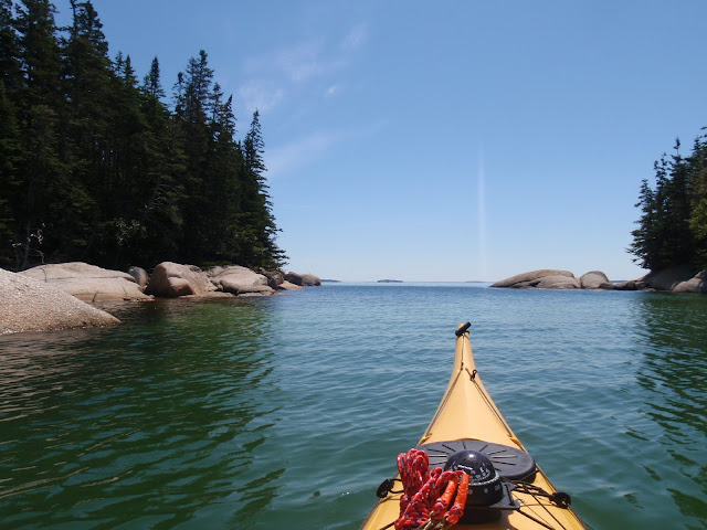
Our Tuesday outing was a remarkably clear day, and we ventured out through the maze of islands to Gooseberry.  This was similar to a trip we'd done last year.  But this year we had an unscheduled convergence with the Each and Everyone blogger and his sparkling blue Capella.
Each and Everyone Blogger arrives at Gooseberry
Friday was unfortunately shorter, but no less enjoyable.  We visited the harbor, and inner islands, discovering a perfect little beach we'd never noticed before.

A few stories; BaffinPaddler asked me for suggestions of where to paddle in Maine. I suggested Stonington, specifically Old Quarry Ocean Adventures. Old Quarry has a beautiful location on Webb Cove.
A view from Old Quarry
Also on Webb Cove is an active lobster facility, which sent over a dozen boats by her tent early in the morning. To be fair, almost all of coastal Maine has that same issue. But never-the-less she was always in a good mood, energetic, ready to head out to paddle and do yoga.
Baffinpaddler was just back from a Paddle to Yoga tour she’d led in the Thousand Islands, and eager for similar adventures on the ocean. She’d also spent a lot of time paddling in the Georgian Bay, off Lake Huron, which in her understated way she mentioned was the “size of a lake.” The size of a great lake, about as big as Massachusetts. She had a healthy respect for the cold Atlantic waters and their mercurial nature.
She made the Georgian Bay area sound very appealing, with its deep clear waters. However as we approached an island, she asked if there were bears there, because on the Georgian Bay apparently bears thrive on the islands. Believe me, I would not be nearly as enthusiastic about Stonington if the islands had bears. And I noted the importance of her recommendation about using a good outfitter with local knowledge on the Georgian Bay waters.

Maelstroms react to the notion of bears on islands

Paddling with two bloggers and four photographers meant a lot of breaks, and some great entertainment while on land as we checked out each other’s artistic visions. We all took photos of a toadstool and a skull. Hopefully Baffinpaddler was happy with her shots, in ours the focus was never right, instead we’ll substitute this picture of the same skull (a groundhog??) on a rock.


We saw many lobster boats and were often surprised at how close to shore they went.  As Baffinpaddler noted, "There is no place where they do not go."  Lobster boats are cautious in the Stonington area, but kayaks are low and not always visible to them.
I am impressed with her yoga visions and projects. We do need to work yoga into our daily lives. Flexibility is key to enjoyable kayaking.
Baffinpaddler prepares herself for yoga on a perch
 
The picture above was taken on Russ Island.  Back when Mark and I made regular runs to clean the island, we always landed on a broad shell beach there.   Here we are on a run in 2007. 
 At first I thought it washed away over the years, but now as I check the rocks and angles, I suspect it is just a tide issue.  We generally would have aimed for a low tide cleaning, that's probably why I think of Russ as having an expansive beach there.

 Fortunately one my favorite sights, the round rock boulder field of Gooseberry, is there at all tides.
The boulder field of Gooseberry
Stonington carries many scars from granite quarrying, where island shores are replaced with granite tailings. Being there always makes me a bit negative toward using granite in kitchens. It's one thing to scar the land for timeless memorials, another for a room which will be redecorated in a few years.
This boulder on Green Island shows how slabs are cut
We’d managed to encourage Baffinpaddler to visit on a week with two high wind days and an impending hurricane! Pretty impressive timing. I hope they can forgive us and come back some day to do other great areas, like Castine and Camden.
A few more photos from our adventures:
A schooner near Wreck

Looking from Gooseberry out to Isle au Haut


An inuksuk

Just a pretty plant

Waiting for a schooner to clear the thorofare
And now, the server battery has only a few minutes left, so I guess I'll post this and make corrections later.

Thursday, August 25, 2011

Ash Paddle


Let Sea Kayaker Magazine explore the world of light composite Greenland paddles.  As usual, Mark is blazing his own trail, eschewing cedar and embracing ash.  And from the smile on his face, he seems pretty happy with the results.

Mark loves Greenland paddles, he even used it when he ran the Kenduskeag race.  But he is tired of sanding the ends of his cedar paddle, and hasn’t had any luck keeping epoxy on the ends. And since he had a plank of ash left over from building a skin on frame kayak (the ribs were ash), he figured, why not move to a sturdier material?

Of course this entailed purchasing a new saw blade to cut it to size, and after several hours of attempting to sand it to shape purchasing a sureform as well.  (A sureform is a blend of a rasp and a plane.)  He made the paddle to the same specifications as his current paddles, same length and width, same loom.  His paddles are asymmetric, one side is flat and the other shaped.
Hopefully this shows how one side is flat and the top shaped
His first draft of the paddle was five pounds, more than a brick.  Since then he’s taken over a pound of ash off.  Oddly, or impressively, enough he estimates he’s only put 8 hours into his ash paddle, not a big increase over the 6 hours he estimates to build a cedar paddle.
Mark using his sureform.  How many pounds of shavings are on the workbench?
Mark thinks that the extra weight works like a flywheel, once the paddle gets going it just keeps moving.  Plus he is very pleased with the toughness of the wood.

I tried using the ash paddle just for a short while.  I did admire the lack of flutter.  I don’t use a Greenland style paddle often, so it usually takes me several strokes to get a flutter free pace.  Not so with the ash.  Plus after just a few seconds of using the ash paddle my carbon fiber paddle felt like a feather; honestly I expected it to float away. 

Another advantage, admittedly untested, is that an ash paddle should be twice as effective as a cedar in fending off polar bears.

Mark tends to be a trendsetter, so I expect that by next year there will be many articles on conditioning, strength building, aerobic capabilities and other advantages of a heavier paddle.

In the meantime, out in the wide world of paddlers, I’m sure there are a few others who’ve played with hardwood paddles.  If you’re one of them, maybe you have some advice to offer Mark?
Another day, another boat - same ash paddle!

Friday, August 19, 2011

Out to Bakers Island

Lifesaving Station on Little Cranberry as seen from Baker
Basics:  Launch: Northeast Harbor, launch on Harbor Drive off route 198, restrooms open 8AM – 4PM.  High 2:20PM launch 9AM, finish 3PM, 13 miles, two long stops.

Under unique natural areas, Maine Delorme Atlas lists the “Dance Floor” as an off-shore pile of huge granite slabs hewn by the relentless action of the ocean.  The “Dance Floor” is not just called that, it actually used to be used as a dance floor.  A desire to see this feature first drew us to Baker Island, located south of Mount Desert Island, Maine.

I assume the custom of dancing by the ocean was started by Rusticators, folks coming to summer in Maine in the 1870’s, eager to enjoy simple outdoor pleasures.  After all, dancing on a distant island hardly meshes with the image of the practical, staid Mainer.  A charismatic young man no doubt organized the first dance, convincing his friends to forgo more logical locations and instead to row across from Little Cranberry, walk through the fields of Baker to the ocean side.  There, no doubt picnic baskets were unpacked, blankets spread out and eventually a fiddle began playing.  And tentatively, couples would dance across the uneven surface, giddy at the foolishness of it all.

To get to Baker we paddled out of Northeast Harbor, a small secure harbor packed with beautiful yachts and sailboats. 

It was a quick jump across the harbor, though a bit of a challenge, as sailboats headed out, but also in (surprising at that early hour).  Our journey to Baker Island would take us by three other islands, with relatively short crossings in between.  Along the way we passed bell buoy 10 and the Bear Island lighthouse.

 Crossings were stressful, especially Bear to Sutton and Sutton to Little Cranberry.  Lobster boats were out gathering their traps and pleasure boats and sailboats rushed through.  At each crossing we’d keep close together, twisting our heads in all the various directions.  We never had a clear crossing; there were always others boats moving through, but we’d monitor them to assure we weren’t staying in their pathways.   At times we felt like we were involved in a big game of Frogger.

As we paddled along Sutton I captured this photo of a cormorant.  Usually I see something I want to record, pull out the camera from a PFD pocket, turn it on, realize momentum has taken me past the shot I wanted, paddle back a bit, point the camera in the general direction and hope the most recent wave doesn’t blur the shot.  So I was amazed that the feathers are in focus and you can even see the eerie jade green eye.

There is a irregularly shaped bar and shallows most of the way between Little Cranberry and Baker Island, which turns gentle swells into crashing waves, but by watching ahead we were able to avoid them. 

Since we often wait until September to paddle off MDI, most of the time when we’ve made it to Baker, we’ve been on our own, but this time there were three boats anchored by the beach on the north side, two pleasure cruisers and a tour boat.  Only one person was visible though, the captain of the tour boat who was fishing off the back.

We landed on the cobble beach, pulling our boats up high and tying them to a large rock.
Before we pulled the boats above the high tide line
We followed the mown path up by the old houses.  Baker Island is partially owned by Acadia National Park and partially privately owned.  Red buildings are private buildings.

Beyond the buildings, Baker Light appears, hidden in the middle of the now forested island.  A few visitors were there chatting with a park ranger, like us they were going further, taking the narrow wood trail which started near the brick building once used to store oil for the lighthouse.

Altogether it’s about a half mile across the island, along the trail we spotted just one fairy house; tiny houses of natural material built in some special locations.  Sometimes there have been several fairy houses; I’m not sure if the builders have stayed away, or if the National Park Service discourages their presence.

I was hoping to hear more details of the Dance Floor, perhaps seeing a brave young couple trying a few steps.  Instead, as we stepped out of the woods into the bright sunlight, we just saw folks sitting and watching the waves. 


We hung out there a few minutes and then headed back, preferring instead to wander by this old cemetery on the north west side.

From Baker we went to Little Cranberry.  Unlike most islands we visit, Little Cranberry has a town on it;  Isleford, and even a small tourist area.  There is a historic museum, public restrooms, a gallery, a gift store, a pottery shop, and a lovely restaurant on the end of the dock.  These are frequented by the year ‘round and summer residents, but mostly from day visitors who come out on a scheduled ferry.
Coming in to Isleford Harbor
One visitor asked us if we’d paddled over, and then seemed amazed when we answered in the affirmative.  She called her friend over to share that we’d paddled over three miles out.  I didn’t feel right clarifying that we’d actually done about 9 miles at that point, since Isleford Harbor was about halfway back.

The trip back was much the same as going out, though there were more sailboats.  And we stopped by this arch on the north west side of Sutton; even near high tide the water was a little too low to consider passing through.

If you’re thinking of visiting Isleford or want to see folks dancing on the Dance Floor, this is a nice link.

Thursday, August 11, 2011

Stonington Maine, with schooners in the harbor


Imagine a clear green sea filled with dozens of islands within a five mile radius.  And then imagine that many of these islands have beautiful white shell beaches, shorelines of pink granite and best of all, the privilege of access, for careful day use, and sometimes the night as well. 

One place which brings these imaginings to life is Stonington Maine.  No wonder it is a popular pleasure boating destination.  The biggest challenge to Stonington is picking a route - because there are so many great choices.  It’s certainly a place where time flies, and all too soon the day is over.

Stonington certainly rates as a not-to-be missed Maine sea kayaking adventure.  We often like to bring paddlers there, in part because there are no strong currents, and the islands tend to provide protection from winds.  Not that Stonington is without its dangers, the ocean is the same deadly cold it is all along the Maine coast, the area has frequent dense fog, and the waters are heavily trafficked by pleasure and work boats (mostly lobster boats.)  And, though the islands provide protection, they are not immune to waves and wind, so those must be taken into account.
We launched from Old Quarry Ocean Adventures.  Bill Baker, who runs Old Quarry, has everything an adventurer could want, for day trippers: parking, launching, and showers; for travelers coming from a distance: rental equipment, for overnight visitors: camp sites and lodging, and for everyone a series of adventure packages; tour to see Puffins, a boat ride to Isle au Haut to go biking(fun!), of course kayak tours and lessons.  And best of all he creates a two sided sheet detailing which islands are available and what restrictions apply, so we don’t accidentally blunder into a heron rockery. It is the most complete and current list I know of .

Stonington has a strong history of stone quarrying.  Granite for the JFK tomb was quarried on Crotch Island, which still has a working quarry.  Granite from Russ Island went to the towers on the Brooklyn Bridge.  Many of the quarries have closed, but the remnants are everywhere.

Proof of the active quarrying was evident when a tug boat shoving a barge full of granite headed up into Webb Cove as we went to launch.
After letting the barge pass through we crossed over Webb Cove and went along the shore to Stonington Harbor.  Gathered in Stonington Harbor were four schooners, the Victory Chimes, American Eagle, Stephen Taber and one other.   What a gorgeous collection of boats!
We paddled up a little further along the shore; a couple of sights on the way;
a lobster boat in the harbor:
this lobster pound in an old quarry:

And this precarious looking pile of granite.

Near the Crotch Island sandbar we came across the skeletal remains of a ship, not listed on our chart.  It was probably close to dead low when we saw it.

There are many, many islands to choose from when it comes to picking a place for lunch.  I like an island small enough to circumnavigate in water shoes, and Mark likes Steves for its delightful views both of the harbor and distant islands.  On our way there we paddled along Crotch Island, whose shores, like those of many islands in the area are piled high with scrap granite.
That rough shore is barnacle covered mussels
A photo from lunch showing  granite, which appears to be melting, on Steves island shore, and quarrying cranes in the distance.

After lunch we went to wander about the island and discovered we weren’t alone.  A pleasant family from Montreal was camping on the south side.  Fortunately, they welcomed guests, and we spent time talking about favorite paddling locations.  They had been paddling many places along the coast of Maine on this trip.  They'd previously been to many other places which made us envious, including Newfoundland, and down the Saguanay River. 
Meanwhile, back in the harbor, the schooners were setting sail.

After lunch we had a quick paddle to Hell’s Half Acre (which is heavily used, but still incredibly lovely) before heading back to the Old Quarry launch and rewarding ourselves with showers.  It is so amazingly heavenly to shower before hopping back into the car.   After a shower I feel civilized and refreshed enough to explore the downtown, or to go out for dinner. 
Those who look carefully at the chart above will note neither Steves nor Hells Half Acre are named on the chart.  Steves is between George Head and Wreck, Hells Half Acre between Bold and Camp.

Monday, August 8, 2011

Naskeag Point, Brooklin Maine

Basics: Best for a Sunday, Launch on Naskeag Point Rd in Brooklin, about 35 parking spaces and one portapottie. Launch 10:30AM, finish 2:30PM 8 miles and a long stop. Potato Island completely loses its beach at high tide.

Yes, there is a Brooklin Maine; it’s a tiny coastal community which bills itself as the boat building capital of the world, a distinction earned mainly through the efforts of the Wooden Boat School. Driving to Naskeag Point takes you right by the Wooden Boat campus, and the launch is impressive right from first sighting, a lovely spit of salmon colored granite gravel edging into green waters filled with lobster boats, a cottage-filled island just off shore.

Across from the parking lot, and just inland from the dock is an apple tree speckled picnic area. A granite marker reads “Battle of Naskeag, reenacted 1976” making it unclear if the park honors the battle of 1778, or the reenactment. link There is also a tribute to fishermen, and a memorial to fisherman.
The launch gravel is compacted well enough for trailers near the dock, but becomes looser further out. This is another harbor used heavily by commercial fisherman. When we’ve been there during the week it’s generally pretty packed. But on Sunday morning, when we arrived just after 10AM, the lot was nearly empty.
Less than half a mile off Naskeag Harbor, tucked behind privately owned Harbor Island is the adorable Seller Island, owned by the Maine Bureau of Public Lands. Camping is allowed there, and it is probably occupied every weekend all summer.

One of the challenges of Naskeag is that there are two busy throughfares nearby, if you head east to Pond Island, you will be crossing into the traffic coming in and out of Blue Hill Bay, if you continue south you’ll cross Eggemoggin Reach, a busy throughfare as well.


Can marking Eggemoggin Reach, Isle au Haut in the distance

We paddled south, crossing Eggemogin Reach near its buoys and continuing on to loop about the Lazygut Islands. There’s something irresistible about paddling in a narrow channel between two islands.


By Stinson Neck


Between the Lazy Guts
Then we headed back to Potato Island for lunch. Like Sellers, Potato is a Maine Bureau of Public Lands Island, but being further out, it sees less use. Sellers and Potato are both islands which demonstrate bigger isn’t always better. Both are small, surrounded by ledge and loose boulders, so that if you are nimble and willing to scramble a bit, you can quickly circumnavigate either island on foot touching only rock surfaces.

Potato has a beautiful shell beach connecting it to ledge, which unfortunately, near high tide was completely underwater. Instead we landed in seaweed and tied our kayaks to rocks.


The white beach is visible, but not available
These are a few shots taken on Potato.


The area has a reasonable number of seals, we spotted a few at a distance. There's also an assortment of seabirds.

In addition to Maine Bureau of Public Land islands, a few privately owned islands in the area allow access by Maine Island Trail Association .
Heading back in was more of a challenge. Not too surprisingly Eggemoggin Reach was busier than when we’d headed out. We waited for a few sailboats to pass, then angled so as to cross behind this red-sailed boat.

A different party was on Sellers when we went by, this time two very serious looking paddlers with enough gear on their decks to imply they were doing a long section of trail.
And, also not too surprisingly, the launch was busier as well, with skiffs ferrying adventurers and their gear in from weekend adventures in their island cottages, and Sunday afternoon paddlers heading out. All in all another wonderful day on the Maine coast.


You can see a portion of Lazygut at the bottom left