Ladle is one of many appealing islands off the Maine coast. Though access is not allowed, its high cliffs with golden lichen draw the eye and begged for closer examination. Ladle is built the reverse of many islands on the Maine coast. Most islands have their rockiest shores to the south-east, but on Ladle the cliffs face to the north, visible from just after our start at the South Addison launch.
The South Addison launch was about half full when we arrived at 10AM on a Saturday. There were several vehicles with trailers, including a commercial kayaking tour vehicle. Our plan was to paddle around some islands then make it to the Cape Split causeway for the 12:15 high tide, portage the narrow road to get back into Eastern Harbor, and return to the launch.
On the way out of the harbor, we captured a decent picture of the ersatz lighthouse.
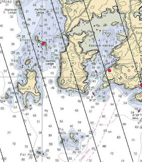
Freed of the harbor, goal one was Ladle Island. It's a short three-quarter mile crossing, and it seemed like most boat traffic preferred to stay outside the Ladle-Norton island area, perhaps because of the many ledges. None of the ragged cliff edges revealed paddle-able caves.
 |
| At the base of the northern cliffs |
The island looks more like a ladle from this angle (to the southeast).
Many guillemots swam about the island; I have no doubt that several nest on Ladle. One last picture of the east side.
Then it was off to Norton and Eagle Islands. About halfway there we happened upon a jellyfish bloom. I assume the moon jellies were torn on one or more of the many area ledges.
Here I'm puttering by one ledge near Norton. Our chart showed a day-marker warning of the outer edge of the ledges, but we weren't able to spot it. Turns out our chart was out of date - it's been replaced by a nun buoy - which we did see.
This is a nice picture of tiny Eagle Island, just north of Norton (left in the photo.) As we paddled up to it, suitably enough, not just one, but two eagles flew in, paused in the trees for a second, then took off for another location.
Lunch was on Sheep Island, owned by the Downeast Coastal Conservancy. It is a lovely island, with a sandy shell-strewn beach, picnic table, fire pit and latrine.
 |
 |
| Beach closeup |
We chose to eat at a shady spot on the beach, where diving terns kept us entertained as we ate.
Another tern picture, this one with a young tern begging for food.
The causeway crossing was fairly easy, although I did wind up slogging through some red seaweed. A slightly lower tide, or not being there at precisely high might improve that, but I'm not sure how it would affect access to Eastern Harbor. The whole northern quarter dries out by low...
 |
| Exploring the peaceful harbor waters |
These residents on Eastern Harbor believe in keeping life fun.
As did several others! We counted nine kayaks in the harbor. (Not that you need to kayak to enjoy life, but it certainly helps...) We never did spot the commercial tour, so I assume they left Eastern Harbor to explore islands.
 |
| A close to full Eastern Harbor as viewed from the launch. |
Summary: Launch South Addison, lots of parking, all tide ramp. No facilities. High 12:15PM. About 6 miles, start 10, finish about 1PM, one stop.


Looks like a great loop to paddle and the beach on Sheep Island looks idyllic.
ReplyDeleteIt was a wonderful paddle, a new area for us with many discoveries. Sheep Island really seems like a great place to take a break or spend the day. I'm grateful that the Downeast Coastal Conservancy has opened it for public use.
DeleteLoved the photos, especially of the lighthouse, the cliffs and the island's ladle shape! Did you have to be careful not to paddle up some jellies when you encountered them? Or did you just steer clear of them? And isn't it great when there's a public spot to get out, stretch and eat your lunch? Nice post!
ReplyDeleteSo far the moon jellies have been to slippery to stick to a paddle. We are careful as we go through them though.
DeleteIt's always nice to have a place to get out. Even nicer to find an island set up for picnicking the way Sheep Island is!
Another pretty spot
ReplyDeleteThank you John.
Deleteas always..lovely photos..
ReplyDeleteThank you, it was a lovely area.
DeleteLooks like a great paddle spot. Awesome pics! Cheers from Canada! Looking forward to fall paddling! Our summer weather up here has been nuts with wind and rain but we have learned to go out anyway :) We hope to catch up with you again for another awesome paddle or two sometime soon or next year.
ReplyDeleteIt is a lovely spot. We have been doing far less paddling this summer, but I hope to post another location soon.
Delete