Sunday, September 9, 2012

Curtis Island, Camden, Windjammer Part 3

    "I love that lighthouse,"  I told Mark, as we rounded Curtis Island.
    "That's because it's round."  Mark replied.  We'd already paddled by Indian Island and its square lighthouse as we left Rockport.
    "And the roof is red." I added.

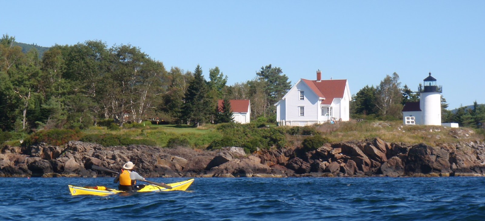
   I do love Curtis lighthouse; it was the November picture in my 2011 calendar, Taken By Paddling.  For this year's calendar, with a  tentative title of "Stick a Boat in it",  I was determined to get a great shot of Mark paddling by Curtis Light.  That's always a challenge on moving water, but I had to try.

  Later, after exploring Camden's inner harbor and the schooners there, we headed back to Curtis Island for a lunch break.  We'd stopped there once before, in 2007, on basically the exact same paddle as we were doing today, Rockport to Camden.  But on that day Penobscot Bay had been still, so the paddle up was a bit boring.  Also, it was low tide, and Curtis Island seemed to be filled with kayaks, so we landed on a side beach.  Good "Leave No Trace" advocates that we are, we stuck to rocky area, and didn't even attempt to scale the slope at the edge of the beach to explore the island.

   This time, with an incoming tide, there was only one gravel beach available and we had it all to ourselves.  At the beach was a set of stairs.  I might worry about the damage caused by scaling a hill, but not climbing a set of stairs.
  At the top, was a kiosk, a guest book, and a sign giving some history of Curtis island. Curtis island was given its name in 1934, named for Cyrus Curtis a long-time summer resident and benefactor of Camden.  

   The kiosk also had a sign declaring Curtis Island a public park.  So we decided to explore, hiking the wide grass trail from the harbor side to the lighthouse.

    "There's someone in the house,"  Mark whispered to me, as grew close to the lighthouse.  I continued forward, spellbound by the opportunity to see the view from the edge.
   As we hiked through the yard, a woman came out of the house.  We stopped, fully expecting to be told this was a private area off limits to visitors. 

   Instead the woman, Dee Dee Conover, had come out to invite us to climb up into the lighthouse!!!!  Heaven!  We talked for a little while about her life out on the island (note the rain barrels on the gutters for water) and then we went off to climb the tower, and she returned to her house.  To get to the top, first you climb a set of spiral stairs,

then a ladder,

After which you crawl out a window-sized opening to get to the balcony.  Curtis Light has a distinctive green Fresnel lens that can be seen six miles to sea.
The light, the hole we crawled through, and if you look carefully along the bottom, the ladder landing

   The first lighthouse on Curtis Island was built in 1836, the current structure dates from 1896.   Once you are on top of the lighthouse, you are standing 52 feet above sea level.  The views are amazing!
A kayak tour out by Northeast Point
The same tour group rounding Curtis: we were up there a long time.
  The lighthouse has been automated since 1972.  Starting in 1980, Garrett Elliot "Connie" Conover Jr and Dee Dee Conover began a long stint as caregivers of the island.  Connie Conover passed away in 2010, and Dee Dee is still there tending.

  The grounds and lighthouse are generally off limits to the public.  A couple times a year, Maine offers Open Lighthouse Days. September 15, 2012 is the next Open Lighthouse Day;  Curtis Light is scheduled to be open then.  Curtis Light may also be open for future Windjammer Festivals

  The entire time we were in the lighthouse, Mark and I were the only ones there.  It was a magical time that will stay with me forever.   Thank you Town of Camden and Dee Dee Conover for letting me have this magical experience!
  More Information:
  Curtis Lighthouse History http://www.lighthouse.cc/curtis/history.html 
  Curtis Island Light http://camdenmainevacation.com/curtis-island-light.php
  Curtis Island Maine http://www.lighthousefriends.com/light.asp?ID=532
 

Wednesday, September 5, 2012

Rockport to Camden for the Windjammer Festival, Part 2


   "Looks like you have a nice day for this,"  the dog walker told us, "Last time I paddled here I got thrown off my kayak out by Indian Island."  She didn't seem particularly concerned, so she must have gotten back on top readily and headed into quieter waters. 
    And we didn't probe into her accident, but spent our conversation admiring her dog and assuring the two hour parking limit didn't apply to our space. 
     Soon we were on the water.  We rounded Indian Island Lighthouse and headed north.  
Indian Island Lighthouse, an abandoned lighthouse on a privately owned island
      And sure enough, freed from the quiet harbor, Penobscot Bay waters were choppy.  Wind was from the north and the seas were interesting but not overwhelming.  There were steeper waves near the ledges to add adrenaline to our journey(watch out for rocks!), and quieter waves inside Goose Rocks to allow faster progress.
   Even before we rounded Indian Island we spotted schooners on Penobscot Bay, and once we'd rounded Deadman's Point a huge naval vessel, the 567' USS Normandy, (CG 60) came into view.  The USS Normandy was built in Maine at Bath Iron Works, and in her maiden voyage served in Desert Storm.  Since then she's been involved in many other missions to protect our country.  The USS Normandy would be our focal point through much of the paddle north.  Along the way we also saw one gray seal, dozen of guillemots and an array of seagulls.

     Camden is another beautiful harbor, a bit more crowded than Rockport. 
Heading into the maze of moorings which defines Camden Harbor
Schooners were heading out on an irregular schedule, one at a time wending their way through the narrow channel left free of moored boats.  I believe this is the Timberwind breaking free
   In the harbor, schooners were lined up along all the piers.  The three larger schooners are:  (left to right) light gray Mary Day, dark gray Lewis R French and the dark vessel is the Angelique.
Schooners, day sailers, and sailboats line up in front of Mount Battie
   Both the Appledore and this kayak group are getting ready to head out.  You'll see more of the kayak tour in our next post.
    Schooners weren't the only boats heading in and out.  Sailboats and pleasure boats headed out to enjoy the beautiful day.  The Pied Piper took passengers out to tour the Normandy.
     Kayaks bobbed about, exploring the quiet areas.  There was even a two person rowing scull.
    Once we were done exploring and watching, it was back to Rockport, stopping to admire the rock walls and sculpture at Deadman's Point along the way.
Rock Gardens at Deadman's Point
This sculpture belongs with the rock walls.
    Waves were from the northeast.  Entertaining, but not ideal for surfing.


     It's hard to say which harbor is prettier; Camden or Rockport.  I do feel like I got a calendar's worth of beautiful photos along the way.
Rockport Harbor
    As we loaded our boats we met a nice couple from North Carolina.
    "So how far did you all paddle today?"  the man asked.
    "Ten miles," Mark replied, "we went up to Camden to see the schooners."
    "Oh, we started in Camden," he offered, "But we walked here."
    "Wow, how far was that?"  I asked.
    "Two miles."

      Further evidence that the sensible thing to do if you're coming from Bangor to the Camden Windjammer Festival is to drive to Camden, find a parking space, and spend the day admiring windjammers and taking part in the many other parts of the festivities.  It's far less logical to drive through Camden to Rockport, paddle along the shore to Camden, glance at the festivities and head back.  Nevertheless we had an incredible time, primarily because the water between Rockport and Camden was so entertaining.

We offered the couple a ride back to Camden, but they wanted to explore some more, or perhaps they were leery of putting their lot in with a couple plainly lacking in common sense.

Next in the Series:  Curtis Island.

Summary:  Start Rockport Marine Park (our post on the launch), fee to launch, flush toilets, pay shower available.  Launch 8:40AM, finish 12:40PM, 10.4 miles; one long stop.  High 12:09PM.

Saturday, September 1, 2012

Rockport Marine Park, Windjammer Part 1


Our first September paddle was so awesome, and generated so many photos that we need to break it up into a few posts.  We'll start with our launch site:  Rockport Marine Park.

Rockport Marine Park has flush toilets, a pay shower,  and a hose for rinsing your gear after a paddle.  There are several parking spaces, a ramp launch, a small beach, docks frequently used for fishing, picnic tables, paths and benches.  There's also a vending machine, right by the building with cold water and Gatorade.  

So, with all those features, you're probably ready to pay through the nose to launch, but before you guess the price wait!  There's so much more!

An elegant bell buoy tipped on its side!

The last surviving remnants of Rockport's Lime Industry, a triple kiln.  Once enclosed by a great wooden shed, these kilns were topped by iron stacks made of boiler plate, which would be filled with limestone.  Most kilns used wood,  burning as much as 30 cords per load.  The Rockport kilns were run with soft coal.    
Close Up of the Kiln

A replica of the Vulcan steam locomotive used to bring limestone to the kilns.  The locomotive ran along a trestle which allowed it to dump the limestone into the stacks.

A fine plaque illustrating the industry, detailing the size of the operation and the tragic event which brought it to a close!

A memorial statue to Andre the Seal!  Andre the Seal was adopted by Harry Goodridge in the 1970's.  He was known for his evening performances in Rockport Harbor as well as for swimming from his winter home at the Boston Aquarium, back to Rockport every spring.  Somehow I missed the statue (Mark may have been saying something about being here to paddle not gawk,) so I will substitute instead pictures from long ago, when I watched the actual Andre the Seal perform.  Andre is the little blob and Harry Goodridge the man in the cage.

Now what would you pay??
Unbelievably, the park is free.  Launch fees are $2 for residents, $4 for non-residents. 

More information about Rockport Marine Park:

Rockin around Rockport http://www.maine.gov/doc/nrimc/mgs/explore/surficial/sites/dec09.htm

Maine Coast Guide: Lime http://www.mainecoastguide.com/sidebars/lime.html

The Andre the Seal Memorial http://www.waymarking.com/waymarks/WM7FT2_Andre_the_Seal_Rockport_ME

Thursday, August 30, 2012

Sorrento to Staves

 To be human is to be curious and to seek beauty.
Paddling on the river is good exercise and, oh so convenient, but it is neither the ocean, nor new territory.  So when Wednesday dawned bright and clear, we took advantage and drove to Sorrento, with a goal of circumnavigating Staves Island.

Sorrento is a tiny town north of Ellsworth.  What a gorgeous launch;  fine boats, multiple small islands just off shore and the hills of Mount Desert Island as a backdrop.  Beside the pier is a crescent beach of fine rock bordered by summer cottages.  The beach is perfect for strolling, or in our case, launching.  A covered picnic table is available for dining at the pier.  There's also this unexpected reminder of days gone by:

We planned a simple looping, Preble, Calf, Little Calf, Thrumcap, Stave, and back along the other side.

Wind was from the west, so it was a quick journey out, with a few lovely views on the way:

The boxy fractures of Preble.
Little Calf with Mount Desert in the background.

I've often admired Staves from across Frenchman Bay.  It's an easy spot from the Hop, at the end of Long Porcupine.  Why?  It's golden shoreline:

On this windy day, with a steady breeze from the west, it was choppy water along the west side.

The backside of Staves was tame;  what a difference in boat glide on the quiet water.

   Three hours after high, we were able to cross over the bars between the tiny twin  islands and Staves easily. 

Past the islands, Black and Schoodic were our backdrop.

After our swift ride down, the paddle back was more of a slog, against wind and outgoing tide.  Bars between Eastern and Sorrento Harbors were barely passable.  We arrived back at the launch covered with the white speckle remnants of salt water droplets, but deeply refreshed by our explorations.

Summary:  Our launch was from the Sorrento beach; we parked at the town pier.  A sign at the pier states:  "Non-Resident Commercial Vehicles May Not Park Anytime in Town Pier Parking Lot or Along Waterfront".  It could well be that next time we are there it just forbids non-resident parking. Off to the side is a portapottie. High 9:15AM.  Launch 10:45AM, finish 2:30 PM 10 miles.

Sunday, August 26, 2012

Kayak Candy and Google Kayak

A couple quick notes in case you've missed them:

Big Lots! is currently selling Caiaques, a dark chocolate, candy-coated, pumpkin-seed shaped treat made by Viera of Portugal.  Unlike real kayaks, these are not improved by being added to water. (Thanks to Katrina for sharing these with us.)

In honor of the Olympics Google posted this interactive kayak doodle.  I've had great luck with it at keyboard computer, almost none running it from the iPad.  (Thanks to BangorBytes for forwarding it to me.)

Wednesday, August 15, 2012

Hot? A few tips from Mark

Tired of feeling hot??  Mark has tried and true ways to help keep you cool:

Try some cooling spray, using the ever popular Skimming Backward Stroke:

 Need to tan your legs and practice a balance brace??  Why not combine the two???

 Bonus points if you can convince others to try - especially if they aren't successful!


Sunday, August 5, 2012

Leech!!!?!!!


   Leeches; disembodied stomachs crawling along waving 300 razor sharp teeth at the end of their tiny necks.  Mouths filled with anticoagulants and painkillers designed to allow them to feast on my blood without detection. 
Leeches; not what I want to see when I pull back my kayak skirt.  And yet it’s happened- twice. 
                                 This little creature is the most recent.

     Oh sure, it looks all innocent and plump, but trust me, it was just waiting for bare flesh to get near it.  Worse, while I was looking for a stick to remove it, it crawled under my seat and hid.

    “Pour some water in your boat,” Mark suggested; being as unwilling as I to reach in after it.

     I tried that, to no effect. 

    “Let’s just put the hose on it at home.”

     With a sigh, I helped lift my kayak onto the car. But, at home, after running the hose under the seat, the leech failed to appear. 

     “Maybe it just crawled away on its own.”

     Oh yeah, I’m going to trust that this little blood sucker is gone and not just lingering under my seat waiting to act out scenes from Stand By Me.  I don’t think so.  

     It took a pancake spatula, and a few minutes of searching, but I made sure my cockpit was leech-free; for now anyway.

A few leech related links:
This Youtube video shows a Maine leech merrily crawling over the surface of a kayak.  I’m not sure if my leech came in off a foot, or if it just crawled up over the side and slipped in; I had not worn a skirt through the entire paddle.
And this article is by Tamia Nelson- who claims to like leeches, and offered the same advice Mark did:  "Deal with it- leeches are everywhere; unlike mosquitos and ticks, leeches are not linked to any serious diseases."  Easy for Mark to say, he’s never been surprised by a leech hiding in his boat.  
How about you??  Leech fan or foe?  Any great leech stories to share??

Thursday, August 2, 2012

Pemaquid and the Thread of Life


Colonial Pemaquid
     The Thread of Life, not a mystical connection, but a series of ledges off Rutherfod Island in South Bristol, Maine. (Chart section below)

   Despite the heat and humidity,  we were determined to paddle somewhere we’d never paddled before; Pemaquid.  Pemaquid is an native word, meaning “long point” or “long finger,” an accurate description of the land.

  The launch is conveniently located beside Colonial Pemaquid.  Colonial Pemaquid is a State Park with two primary attractions: a reconstructed Fort William Henry and a museum displaying archeological findings from European Settlements in the area.  Like many places in Maine, Pemaquid was settled first by native tribes, then used as a seasonal settlement/trading post by Europeans.    Permanent villages of European settlers date from 1625.  

    The boat launch is beside the state park.  It has one long row for vehicles with trailers, another for cars.  It seems popular with kayaks of all types.  The launch is into the Pemaquid River; several recreational kayaks were taking advantage of the quiet estuary.
The landing when we returned
   Our goal for the day was the Thread of Life.  These ledges create a challenge for sailors to navigate; not so much for kayaks.  A search for the “Thread of Life, Maine” on Google brings  up many lobster research links because the University of Maine’s Darling Marine Center, does a lot of lobster research in the area.  In fact, we saw one of their boats out there while we were paddling.

Things we noticed along the way:

   Very calm seals.  Usually by the time we spot seals, they are unhappy.  Not this set, we didn’t get any closer, but they seemed content to stay on Knowles Ledges.  More were hanging out as we returned.
    Paddling into wind and waves is definitely refreshing.  Between the salt spray and wind, we were comfortably cool.  But it is also tiring, so we ducked behind the many mini islands along South Bristol.  That took care of the waves, but the wind was still around.

   As in the days of old, South Bristol still seems to be mainly a seasonal  settlement, but what wonderful and charming residences!

   The clever folks of South Bristol enjoy their cliffs.  Some have build fences by the sitting areas, others keep cliffs practically at their back door.
    There are not many places to land along the South Bristol shore.   One possible landing is Witch Island,  an occasional destination of the Pemaquid Water Association Paddlers. (which hosts paddles every Saturday) There’s also another small beach, listed in a book, Kayaking the Maine Coast (2nd ed.) by Dorcas Miller.  When we arrived, the beach was occupied by a very pleasant young family.  They seemed set for the day with two big coolers and assorted bags of stuff.  We did the typical dance of the second party to arrive: crashing the beach, thanking them for allowing us to join them, eating quickly and scurrying on our way.

    The Thread of Life has some pretty rocks on its shoreline; but with the wave action, most appeared as a blurs on our cameras. 

   But we did manage to capture this osprey family.

   The water was a bit rough out there.  Ledges make for tricky water, and the further out you get, the bigger the water gets.  I sometimes think kayakers famous last words are, “Let’s just circle ‘round this island and head back.”

   We came back the way we came in, but much faster with wind and waves behind. 
   Wind definitely trumped tide that day.  Johns Bay seemed wide enough that I didn’t think there would be a lot of out-flowing current, but I was surprised not to see any.  All the buoys and other current indicators were following the wind.
Crossing to Johns
     We stayed on the South Bristol side on the way back because the coastline seemed more interesting.  But after the paddle we drove to Pemaquid Point, to join the many others photographing this beautiful site.  This was my first visit to this lighthouse.  I include this photo so you can see why so many visit here.

  Summary:  Boat Launch beside Colonial Pemaquid/Fort William Henry.  Currently free, though they seem to be building a fee collection point further up the road.  Toilets are available at Colonial Pemaquid.  No fee to get to toilets, $2/person to enter fort/museum.  We launched at 10AM (just about high) and finished at 2PM.  One short stop.  Just over  11 miles across Johns Bay and around the Thread of Life.  It’s also $2/person to get into the park by Pemaquid Point Lighthouse; where there are also bathrooms, an art gallery, a fisherman’s museum, a very friendly staff  and sometimes tours of the lighthouse.