Showing posts with label Fort Point. Show all posts

Saturday, June 4, 2011

Paddle to the Sea Part 4: Fort Point to Wadsworth Cove, Castine Maine

Basics: Launch Wadsworth Cove, Castine, Sand Beach, Seasonal Portapottie.
Alternative Launch: Fort Point $2 entrance fee, long portage, Outhouses.
High 1:30PM Launch about 10:20 AM, Finish about 1:30PM 12 miles.

For the fourth leg of the paddle we opted to do a back and forth trip. The Penobscot Narrows bridge is the southernmost bridge on the Penobscot River so positioning cars for a one way journey between these two locations would mean a lot more driving than we cared to do. This trip is derived from Ray Wirth’s trip to Castine, and might more properly be called “Paddle from the Sea.” You see, winds were coming from the north, though they were projected to switch to south winds later in the day. Still, rather than being optimistic and starting at Fort Point and heading to Castine, we decided to start in Castine and head north, counting on a continuing north wind to overpower the effects of the incoming tide and aid us on our return journey.

We arrived at Wadsworth Cove at 9:50 AM, and it was still pretty chilly, just 55 degrees F. Wadsworth Cove is named for Henry Wadsworth Longfellow’s grandfather, General Peleg Wadsworth, who in 1781, after being captured by the English at Thomaston, Maine, escaped confinement in a cell at Fort George, and earned his freedom by wading across the cove.
The morning wind was steady and cooling (which we really didn’t need.) And, honestly this stretch of water looked to be pretty bland. But we’d set an arbitrary goal, so there was no looking back. We loaded our kayaks and headed resolutely north, aiming first for a classic estate set on the Cove.
As we came out of Wadsworth Cove we spotted our first seal of the day, playing in the water. Off to our left was a mysterious white patch in the water. Some sort of foaming caused by currents?

We crossed from Wilson Point, just south of Morse Cove. I was a little worried about crossing to the ledge marked on the chart because I didn’t want to disturb any seals. We’d checked the ledge with our monocular and cameras without seeing any seals, but to be sure we aimed for the lighthouse and not the ledge.

As we got closer we could see that at this point in the tide cycle the ledge was almost completely underwater, but a few hundred feet from Day Marker 2 a solitary seal hung out. The rock beneath it was no longer visible, but it held its head and tail as high above the water as it could reach, trying to get a few more minutes of warmth from the sun. We kept our aim well north of the day marker, and the seal remained poised on a sliver of rock.

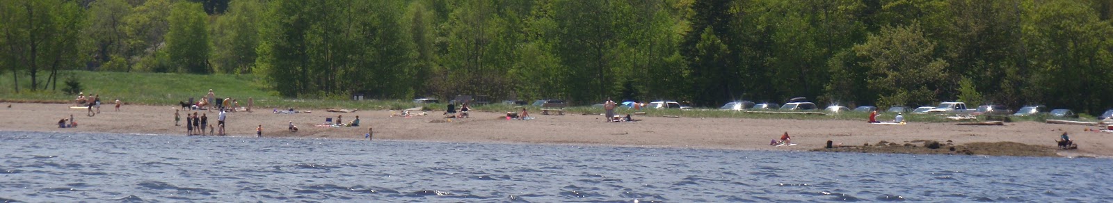
Fort Point has a bar of sand which I generally take to be the mouth of the river. Fannie Hardy Eckstorm reported that the Penobscot used that bar to record information about paddling groups as they commuted from their winter community in Old Town to their summer residences on Penobscot Bay. She claimed they never camped there for fear of disturbing these records.

We met a nice couple at the beach. They were looking for Sandy Point, visible across the cove. She was a decedent of someone lost on a boat that sank near Sandy Point, one of dozens of American vessels sunk by the English at the conclusion of the Penobscot Expedition. (Not all by Sandy Point.) He was a treasure hunter. In Penobscot Down East Paradise, Gorham Munson mentions gold hidden by pirates along Sandy Point, so perhaps they would find that treasure as well.
Looking north toward Sandy Point
We were also entertained by several ospreys. Two ospreys had built a nest on a nearby can buoy, and a third osprey seemed to be worrying them. They flew several challenges over the eddy lines, edging each other in flight but never actually contacting.

After lunch, to our surprise, the wind hadn’t changed direction, so we took off with the wind to our backs. The ledge by Day Marker 2 was completely below water, so we had a chance to investigate the granite structure. It was still providing refuge to cormorants, pigeons and one black gull.
While we inspected the marker several seals popped up to investigate us.
A sea gull, lobsterboat and seal converge for a photo opportunity
Our crossing was uneventful; there was almost no boat traffic. We glided back by the same houses we’d passed earlier in the day, admiring again this cute beach house with its nearby cupola.
Whatever currents had created the disturbance in the water had moved on.

As we grew closer the three spires of windmills on Vinalhaven became visible, much high than the rest of the distant island.

Wadsworth Cove was much as we left it, mostly unoccupied on this cool day. A committee of ring bill gulls, the most playful of Maine’s gulls was waiting to greet us.
And because it was nearly high, we took some time to explore a mill pond hidden behind this bridge.
At the rear of the pond we followed Bog Brook to within sight of Route 15, before finishing our journey, back where we’d started several hours earlier loading up our boats and heading home.
Google Earth showing from Verona Island to Wadsworth Cove: The route marked is Ft Point to Wadsworth Cove

Tuesday, May 31, 2011

Paddle to the Sea Part 3: Verona to Fort Point Maine

Basics: Verona Island landing: Plenty of parking, no facilities (public toilets are available along the harbor in nearby Bucksport)


Fort Point State Park: Stockton Springs $2 per person entrance fees. Pit Toilets. Not technically a launch site and a rather long haul to the water.

High Tide: 10AM. Launch 12:20PM, finish 2:04PM, 8 miles.

What a difference a week makes! Our third leg would be on a bright day with temperatures in the 80’s. Rather than barely seeing the far side of the river, we could easily see four miles ahead. Rather than cringing as we waded in to launch, we welcomed the cooling powers of 50 degree water. This leg would take us from Verona Island to Fort Point in Stockton Springs.

This is the trip I looked forward to the most. I’ve been along Verona Island many times, but generally at peak or ebb tides. Today we’d be riding at mid tide, flying through the Penobscot Narrows. For as I taught Webelos again and again, the Bernoulli Principle states that water does not compress, so where it narrows it flows faster.

It is also one of the most scenic areas, with Fort Knox, the bridges, and Sandy Point, as well as the high banks which caused the Penobscot to once be known as the “Rhine of America.”
We started at the Verona Ramp in a confused back eddy created near the island. A pleasant whiff of crushed wood fiber from the Verso plant confirmed that the wind was from the north. Cormorants and seagulls decorated nearby rocks, but not a single buzzard was in sight.

Soon we were in the downstream current, which didn’t seem too bad by the bridges, but was easily dragging this buoy under.
New to the shore was this cross.
Old to the shore were the bright rocks and high walls. Overhead a flock of young ring bills passed by, one after another, their brownish bodies dark against the sky.

We clung close to Stockton Springs shore. I couldn’t help but look longingly to Odom Ledge and what looked to be several seals there. But pupping season is near, if it’s not already here. Seal pups nurse as few as 14 times, and cannot afford to miss a feeding. Since seals are often nervous in the presence of kayaks we wanted to stay at least a quarter of a mile away.

In place of observing seals, I watched the crowds at the beach. What a rarity, to have such a warm Memorial Day! Sandy Point is a free beach located in Stockton Springs, and a sandy beach to boot. Since it’s in a cove, it does not have the strong currents we enjoyed further off shore. There is plenty of parking, but no facilities.
Just below the beach was an abandoned set of pilings which have become a nesting colony for cormorants. My guide books describe cormorant nests as large and bulky, but they seem pretty basic compared to the more ostentatious nests of eagles and osprey.
Next were the beautiful shore houses of Sandy Point. We pulled out of the current to inspect this solidly constructed boat house, and admire the other houses.
A tall dune marks Sandy Point, atop the dune was a gazebo belonging to Hersey Retreat. That dune is a glacial esker, which has been eroding away, creating the sandy beach along the shore.

Beyond Sandy Point was a deep cove. We intended to follow along the cove shore, but we could hear a seal barking in caution. I didn’t see any ledges on the chart, and the shoreline seemed to be mostly marsh, but the sounds of distress were obvious. Rather than disturb a seal we opted to paddle straight to Fort Point. And what a great ride it was, with the wind to our backs and waves perfectly designed to aid us without requiring too much attention on our part.

At Fort Point folks were also out in abundance. Swimming is not allowed at Fort Point because of the strong currents. We rode those current out and took a few pictures of the lighthouse, before returning upstream to the dock.

It looked like it would be a challenge getting our kayaks to the top of the ramp, so instead we hauled them up the bank, which was also not an easy task.
A final picture of a sailboat at the base of Verona Island

Friday, October 15, 2010

Stockton Springs to Fort Point (Maine)

Basics: Launch: Stockton Springs, restroom still open, portapottie still in place. Lots of parking. Launch 11:15, finish2:45 Low 10:45AM, 10.5 miles
There seem to be more and more challenges to paddling. Usually we like an early start. But 35 degrees? It seemed chill so we waited until it warmed up some, even though winds were expected to increase as Thursday went on. Winds from the southeast, which would be a 60 degree angle to most of our planned trip home. By ten, it was flirting with 50, so we headed out in our wet suits and waterproof boots to Stockton Springs.

The harbor was a busy place, a raft was moving about pulling up the moorings, owners were coming to pull their boats to shore. As we headed away we could see the Pentagoet, the Maine Maritime Academy tug, busy with a barge at the platform near Sears Island.
Stockton Springs' Harbor is basically a big bowl with a half mile wide opening between Sears Island and Cape Jellison, protecting it from many winds and waves. It’s not immune to wind and waves though, we’ve gotten there and changed our minds.
This photo shows the entry to the bowl bordered by Cape Jellison to the east and Sears Island to the west. In the distance, the island of Isleboro breaks up waves coming from the south.

The sun came out, the water was so still near Defence Point at the southernmost tip of the Cape.
Defence Head, low tide
I love low tide on a still bright day, having an opportunity to see what on the sea floor. In the shallow depths some sea urchins and periwinkles remained.
Visibility was high, here Camden Hills peaks over Northport beyond the tip of Sears Island.
Defence Head, a tiny tidal island has a field of rocks at the end of it. It was still close enough to low that we needed to paddle an extra half mile around the island and its bar.
Because wind was expected later in the day, we debated whether to head to Fort Point, or whether to hang around in the harbor area. But we’d seen several boats heading in and out, as well as the student tugboat. We decided to keep to our plan, and headed off along the cliff studded south side.
Mark complained that he had to struggle to keep up with me. At first I thought it was just because I was in the Vaag, but as I thought about it, I’d been in the Vaag on a couple of paddles recently, and neither time had Mark mentioned trouble staying ahead. Once we’d even switched boats, so I knew on flat water they both went about as fast. Still, plainly the Vaag caught the wind better than the Zephyr. That didn’t bode well for the return trip.

Soon enough the Fort Point lighthouse came into site.
We moved into the mouth of the Penobscot River, with the Penobscot Narrows Bridge distantly in sight, and pulled over to the sandy bar. Not a beach, swimming is not allowed due to dangerous currents, especially on an outgoing tide.

Right off the bar was a birch tree with no less than 4 woodpeckers jumping about the branches. I didn’t know what they were eating, not wanting to get close enough to disturb them.

Fort Point is a state park and historic site, with a picnic area, pit toilets and foundations of two forts available for a low entry fee. It is just a short drive from the launch point. We ate our lunch and wandered about, joining other photographers taking pictures of the area, and watching the wind build.
The Bell Tower at Fort Point

The wind never was too bad, but there was wind and chop on the way back, which regularly slopped over the deck or up my left arm. I was pleasantly surprised to find the ocean was still quite warm. It never got above 60 on the trip, but I didn’t need gloves. I used a low short stroke heading back. The wave angle was such that I didn’t need to make many correcting strokes. This time, Mark had no complaint about keeping up, instead I fell behind. Partly that may have been the effect of wind on the Vaag, but I’m sure it was also that wind makes me more cautious. Still we made good time, much better time than getting to Fort Point, mainly because it was too choppy to waste time on photos.

The water was high enough to make Defence Head once again an island, and to allow us safe passage closer to shore without hitting any rocks.

Once between Sears Island and Stockton Springs we made even better time. The waves were less, but the wind and incoming tide pushed us along, and the chop was significant enough that we paddled quickly to keep our boats under control.

The Pentagoet was still towing the barge about and docking at the platform. The mooring pulling was still in process, as was the boat removal.
I was grateful that the restroom with the nicest view of any boat launch was still open so I could change into dry clothes for the trip home.

Time from launch to Fort Point: 11:15AM-1PM. Time to return to Stockton Springs: 1:30PM to 2:45PM. We’ve gotten used to picking the best day of the week for ocean going trips; best being defined as warm, clear and low winds. So it was nice to be reminded that less than perfect conditions are still fun.