Showing posts with label Fresh water. Show all posts

Sunday, June 28, 2015

Kennebec River, Augusta ME: Wildlife and Current


Beach beside the launch.  That tiny white dot by the bridge piling; a sturgeon jumping or an osprey diving?
  If you're in Augusta, even if you're without boats, you should stop by the boat launch under the Memorial Bridge.  There's a small park there, trees for shade, a playground, picnic tables and benches looking over the river.  And a great variety of wildlife;  we saw osprey, eagles blue heron, herring gulls, mink, and ducklings.  But we were there primarily to look for sturgeon.  Large 3-4 foot long sturgeon, which for unknown reasons jump straight up out of the river, primarily in late June and July.  And, while you can just sit on the shore and look for sturgeon, if you have a boat available, it's also fun to play on the Kennebec River.

     Augusta has about a five foot tidal range, we were there about an hour before low, with a swift moving down river current, and a moderate south wind acting against it.  Noting the eddylines, we choose to ride the current down to buoy 82, cross there and wend our way back using old boom islands to assist us.


  Just above buoy 82 are some great stone buildings, the old Kennebec Arsenal, built between 1828 and 1838.  These structures were annexed by the nearby Maine State Hospital in 1905, and abandoned in 2004.   Note the wonderful broad ship landing, and the elegant copper structures capping the ventilation shafts.  It's a beautiful property, awaiting redevelopment.   


Picking my way back upstream behind boom islands, the launch is just beyond the bridge
    Having made it back to the launch in a reasonable time and with a reasonable effort, we headed north, past Old Fort Western.   Fort Western was built in 1754, and is New England's oldest  remaining  wooden Fort.  A bateau associated with the fort was docked at the landing.


    We made it up to the railroad bridge before reaching a point of no further progress, then crossed the Kennebec and rode down to the buoy again.

Gliding by the Old Augusta Post Office and Courthouse, the mink was hiding along this shore

  Along the way we probably saw ten or twelve sturgeon jump, including a few really big ones.  We didn't get any pictures, but Linwood Riggs, a patient photographer, has captured several jumping sturgeon.  Our wildlife photography was limited to some gangly ducks hoping for a handout.


  It was a delightful evening, temps in the 70's, low humidity, incredible architecture, amazing animals and just a great time to play on the water.

Summary:  Launch:  Augusta Boat Launch, off Howard Lane.  Concrete ramp, kayak condos, several parking spaces shared with a picnic and playground area, porta-potties.  The Augusta Tide Chart is here, it's far enough up river to have a very different tide from most places.  The loop with the extra section was 2.5 miles.

Links:  Kennebec Arsenal  http://www.fortwiki.com/Kennebec_Arsenal
           Wikipedia Kennebec Arsenal:  https://en.wikipedia.org/wiki/Kennebec_Arsenal

Sunday, June 7, 2015

Moosehorn to Hot Hole Pond, a Nalu Test


 Having gone to the effort of dragging the Nalu's back up our hill, we figured we may as well take them out in their ideal test environment, a shallow stream with lots of obstacles. 

   The route we picked was a short one, on the Bucksport/Orland line.  Our trip would take us down Moosehorn Stream until it met up with Hole Hole Stream, then up Hole Hole Stream to tiny Hot Hole Pond.  The backdrop to our journey was Great Pond Mountain, whose land held by Great Pond Land Trust

  Moosehorn Streams builds up a little speed as it passes under the bridge by the launch, but for the most part it is relatively slow and shallow.  The bridge is fairly scenic, new cement over what looks to be old granite supports. 

    
Moosehorn Stream runs through a mature forest.  

At the confluence with Hot Hole Stream, there was a beaver dam, which the Nalu crossed easily.  At that point the two streams flow into Alamoosic Lake.

But rather than head into the lake, we turned upstream on Hot Hole Stream, heading out into a marshy landscape.

  It was June in Maine and we were paddling on clean water.  I expected hoards of black flies.  I don't know if it was the temperature ( mid 50's) the gray sky, or the gentle breeze, but few bugs were spotted.  Instead we enjoyed other marsh denizens; red winged black birds, swallows, and grackles.  A pair of geese and their goslings kept a careful eye on us, and a solitary deer wandered along the stream edge.  Unfortunately, none of those pictures came out well, so I will spare you the blurry renditions.
Circumnavigating Hot Hole Pond

    Hot Hole Pond is a smallish pond, it's a place where you can spend the entire day; fishing, hiking, paddling and more.  A group of six canoes had claimed the beach area, and seemed ready to spend a day there.
Picking a route downstream

   The Nalu's did very well on the journey.  Mostly the trip was done standing on the boards, though some tricky areas required kneeling, and I sat for awhile while circumnavigating the pond, just to rest my knees.
A short carry to finish

Summary:  Launch 9:30AM, finish 11:30AM.  Launch where Bald Mountain Rd cross Moosehorn Stream.  Side of the road parking, no facilities.  3.4 miles to and around Hot Hole Pond and back.   Map of the area and trust land

Tuesday, November 11, 2014

Weeki Wachee Springs, Florida


Weeki Wachee Springs starts at a big Florida State Park famous for mermaids.  Behind the state park, Paddling Adventure rents kayaks to folks to ride the spring waters down to Rodgers Park.  In 2012, we just that.  On the way down stream we met several canoes and kayaks headed upstream.  And that seemed like much more fun, working against the steady  1.5 knot current, then riding the cool waters back to the start.

  So this year we started at Rodgers Park, about 4 miles down from the beginning, and began paddling upstream.

  We started early, because the air was cooler and so we wouldn't have to dodge downstream kayaks.

  The paddle began pleasantly enough, we paddled by an array of canals providing water-access to various neighborhoods.  Along the main river, folks sat out enjoying leisurely Sunday morning coffees while overlooking the river.  If they were annoyed to see paddlers disturbing their breakfasts, they were gracious enough to keep it to themselves.

   But as we reached the edge of the development, where the wider stream capable of hosting motorboats faded into the more natural river we had to work harder.  The current was strong, and the stream narrow.  The edges, where the current should be less, were blocked from our use, either by low branches, or shallow water, which couldn't accommodate our 9 inch fins.

  By about two miles up, beating against the stream had lost its luster, so we turned around and flew back.
Headed downstream, the river is a 3-4 feet deep, not the few inches it appears in this photo
   I did feel that we might not have had the right boats for this adventure.  To keep up our gains against the current we did wind up needing to sit/kneel a good bit of the time.  We wound up doing about 4 miles in total, which is pretty standard for a paddleboard venture, but I knew with kayaks we'd have made it further.
   On the plus side, our boats were very light and we were able to store them inside our van.  Although they weren't ideal for this water, we were able to be on the Weeki Wachee before it was too hot, and before the river was filled with canoes and kayaks headed both directions; and I did feel like I'd put enough effort out to deserve a swift ride downstream.
Fishing boat with 2 dogs.  This was followed closely by 2 canoes, with 2 dogs each. 
Links:
Rodgers Park:  http://www.co.hernando.fl.us/parks_rec/Parks/Park_detail.asp?Key=22
Weeki Wachee Springs State Park http://www.weekiwachee.com/
Paddling Adventure :  http://www.paddlingadventures.com/

Summary:  Launch: 8:45 AM from Rodgers Park, finish 10:30AM   4.2 miles.  Launch from Rodgers Park, fee to use, toilets, picnic area and swimming available.

Monday, November 10, 2014

Chassahowitzka River, Florida


  Chassahowitzka River runs five miles to the sea.  Fed by several tributaries, in Google Earth it looks rather like a haunted tree., or an inflamed coronary system. 
  We  startied up by the big yellow pin, which marks Chassahowitzka River Camp, and spent most of our morning exploring the minor tributaries, including an especially narrow one known as the Crack.
"Chassahowitzka"  translates as "place of the hanging pumpkins" which is an interesting visual to imagine, but not a sight we happened upon.
  I'd called the camp the night before, and the answering machine informed me the store was open from 8AM-5PM.  We were there shortly after 8, and a bit behind several fishermen.
  We headed upstream first, to a collection of springs known as the seven sisters.  The water was not very deep around the springs.  I've read that several of the springs are connected by caves.  A rather grim little sign off to the side commemorates those who failed to navigate the caves safely.
   This picture isn't great, but it shows how close to the surface and tempting one of the caves is.
  After exploring those springs we headed downstream, keeping mostly to the right.
  This is a view as we headed by an island.
  A number of birds graced the area, there were several osprey, a few eagles, some wood storks and tri-colored heron.   This raccoon was the only mammal we spotted.  He looks like he might be bowing.
  The furthest downriver we went was the mouth of Potter Spring Creek.  On the Google Earth picture above, that's the tributary that nearly touches the top.  At the end a tiny creek disappeared into the woods.
  We followed the clear running water further and further, until at last we came to Potter spring, a small spring with just enough space to spin the boats, and plenty of mosquitoes.    This labeled map shows the location of the spring off to the side.
   Then it was back to the main channel, where more boats were headed out to explore.

    The Crack appears in many descriptions of the river;  again it's a narrow channel which leads to a spring.
 The Crack is so shallow and twisty that near the top we had to get out of our kayaks and tow them behind.  A the top of the Crack is a good sized swimming hole, but it already had a number of picnickers in attendance, so we moved on.
   Back at the main channel, it was apparent that all the other boaters were out.  Groups of kayaks streamed by, boats raced down the river, there was even an inflatable paddleboard.   My favorite was this paddler who seemed unaware that a predator was close behind.
  With everyone else on the river, it was time for us to head ashore.  The Chassahowitzka had been a fun river, a briny environment where crabs were frequently spotted.  The waters, especially in the tributaries, were often shallow, so I was glad we weren't on our paddleboards looking to find a path for the nine inch fins.  The many creeks give lots of places to investigate, I felt like a jungle explorer.

Links:
Chassahowitzka River Camp
A nicely labeled map of the river :  http://www.chassahowitzka.net/rmap.htm
Chassahowitzka River Wikipedia

Summary:  Launch and rental from the Chassahowitzka River Camp at about 8:30, finish about 11:30.  Bathrooms are available at the store  Low was earlier in the morning.  We wound up paddling about 8 miles. 

Saturday, November 8, 2014

Withlacoochee River to Rainbow River, Dunnellon, Florida

  "Withlacoochee"  means either "crooked" or "big-little" river; "big-little" describing the river as a series of streams and lakes.  There are two Withlacooche River's in Florida, the north one, which begins in Georgia and joins the Suwanee River, and Withlacoochee South.  Withlacoochee South begins at Green Swamp, near Polk City and moves north and west for 141 miles before entering the Gulf of Mexico by Yankeetown.   The river passes through several preserves.  Expedition paddlers should be aware of the 76 mile long paddling trail along the river.  A whole series of charts is available here. There's also a 46 miles long paved trail which borders part of the river.

 We didn't do the entire paddle trail, (I don't suppose that's any real surprise) instead we just did a short shady section.  Unfortunately, the section we did was just beyond where the trail ends, so we used a screen shot from Google Maps to guide us.
Map:  Goldendale is the green dot, Centennial is just west of 41, and we turned around at 484, by the canoe logo. 

  Even though we were doing a short section, we chose to rent longer kayaks for the trip.  We rented from Aardvark Kayaks in Crystal River, the same Aardvark Kayaks, owned by Matt who guided us through Ozello in a prior visit.  It was a last minute decision, so most of his fleet was out, but he had some nice Eddylines for us to use: a Fathom, and a Raven.  Yes, they were more boat than the water required, but they were a fun paddle.
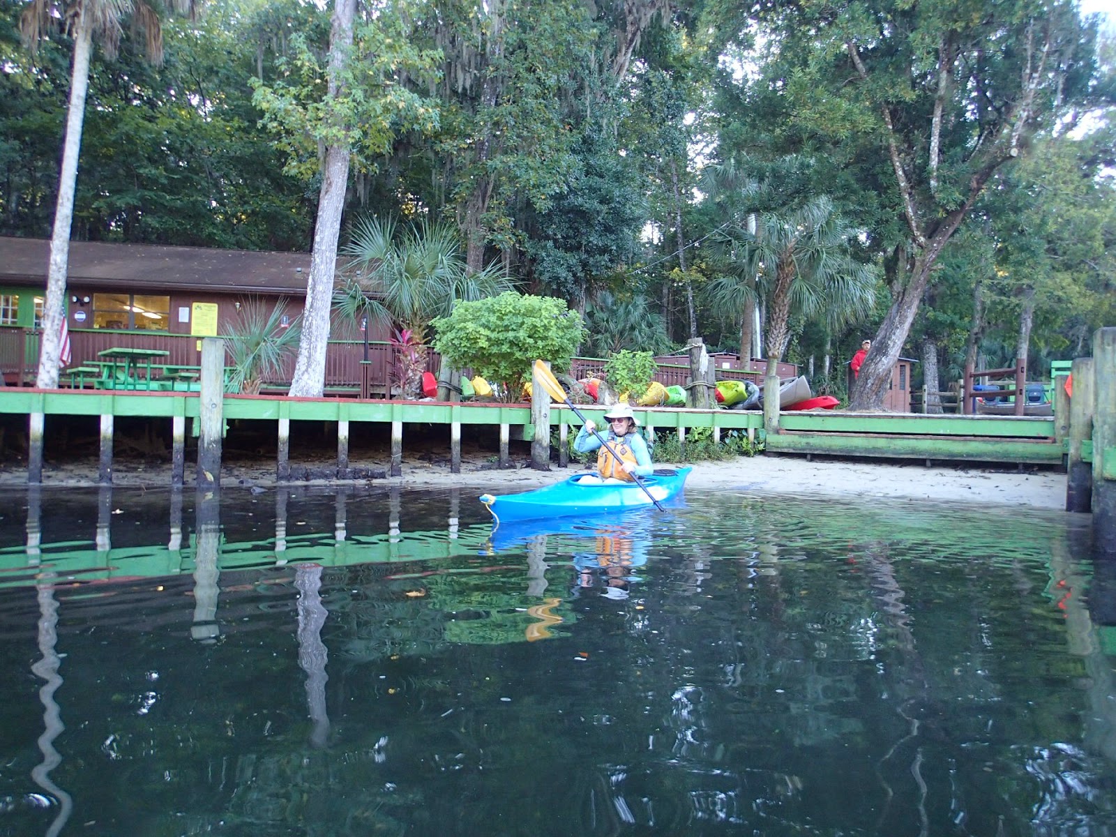
The launch at Goldendale
     We began at Goldendale Boat Ramp,a few miles west of the last ramp shown on the Florida trails map.
  It was a quiet, peaceful ramp, the road lined by live oak draped in Spanish moss, which even at 10AM cast shadows over the launch area.


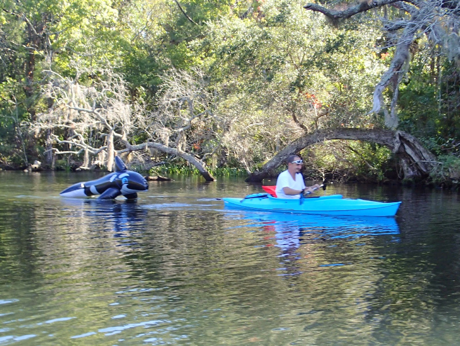
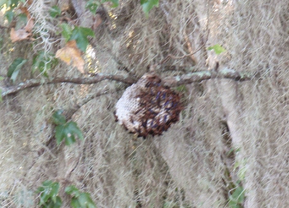
    And it was a quiet shady paddle.  We spent some time in the wider center canal but, to avoid bass boats and find more shade, we often chose to paddle the tiny side canals.  Turtles and herons were sprinkled along the shoreline, but there was also this:

  It's a paper wasp; Polistes annularis.  Like other paper wasps, it likes to build nests over water, to minimize sunlight on the nest.  Though this wasp is found as far north as New York, and west to Texas, unlike the paper wasps I'm familiar with, it doesn't build the insulating overcoats.   But it does cluster many nests in the same area.  And what I saw along the Withlacoochee was small nest after small nest, one per tree, each a few feet off the water, just waiting for a shade seeking paddler to hit.  So you've been warned...

    We took a break at Centennial Park in Dunnellon, plainly the launch site of choice.  While we rested, kayaks and motor boats came in, and their replacements launched, while one motor boat rumbled over and over in the vain hope that this time the engine would catch.
  
Look there are air boats too!  I'm headed downstream and Centennial's ramp is just on the other side of the bridge.
  From Centennial Park is was a short distance to Rainbow river, where the clear spring waters joined the tea colored Withlacoochee.

    As I had while paddleboarding  two days earlier,  I could again see turtles and fish swimming beneath me.

  This cormorant was standing guard on the cedar as we went upstream (within 6 feet of it), and was still there when we headed back.  We nicknamed it the "toll collector".

   Sand Hill Cranes occupied an island in Rainbow River.
Two out of three cranes
 We didn't go far along Rainbow River,  just to another kayak launch, at SR484, before turning back.
  A cool discovery on the return trip was this neat little alligator sunning itself on a mat of grass.
   A closer look determined that it wasn't just one little gator, but a few more.  We then realized there was probably a mother gator somewhere nearby, and continued on our way before the little guys could start clicking in distress.
How many siblings can you spot?
    All in all an entertaining paddle; lots of varying wildlife, plenty of shade.  Another adventure displaying the great variety in paddling options in the Crystal River area.

   Links:

Withlacoochee River Florida - Wikipedia
Withlacoochee River (south)  Paddling Trail Charts
Polistes annularis wikipedia 

Summary:  Launch at Goldendale Launch, parking for for about 10 cars, no facilities.  Stop at the launch at Centennial Park, Dunellon.  Toilets, water, picnic table and more parking available.   9.6 miles by our GPS, unsure which canals we used. 

Meanwhile in Maine:  Our power was restored late Wednesday by a hard working crew.   I thought we might get a paddle in, but it was just in time for a couple of cold rainy days.   We've trimmed and moved fallen branches from the yard, the road and the path to the water, and when we're done with that we're usually achy enough for the day.

Tuesday, November 4, 2014

Sunrise on King's Bay


Absolutely the best thing about having the paddleboards with us was being able to go for early morning or late evening paddles.  We were able to do one or the other most days we were in Crystal River.

  On past trips to King's Bay, a highlight has been Three Sister's Springs.  We didn't get there at all this trip.  Mornings and evenings coincided with low tides, and the access to Three Sister's is rocky, the sort of situation which results in face-plants.

  Instead we wandered about, visiting Hunter Springs, Christmas Island and Buzzard Island.  Never too fast, we just strolled about looking at the water and shore.  As King's Bay has fresh water springs, but connects by Crystal River to the gulf it gets a wide variety of animals.  We often saw  skates, crabs, mullet, ducks, cormorants, anhingas, pelicans, ibis, grackles, buzzards and manatee.  I've got a few pictures to share:
Some ibis showing off
A young night heron(?) by Buzzard Island
Anhingas and Cormorants decorate a tree by Christmas Island
A young manatee passes by
    The light of the "magic" hours enhanced everything in the bay:
Scallopers at dawn
Palm Trees on Buzzards Island (a National Wildlife Reserve)
A variety of house styles along the waterfront
Fishing boats at sunset
   And no matter how early we were on the water, dive and snorkel teams were already out.  I think the manatee encounter boats began their morning trips at 7AM, we'd usually wait until 7:15-7:30 for better light.
All in all the perfect way to start or end any day.

Postscript: sitting here by the fire listening to the wireless modem beep its way to powerlessness makes these pictures all the more delightful. It was a surprise to see 14 inches of slush on Sunday, less of a surprise that many trees toppled, including some onto our power lines. Fortunately the weather is not too cold, the wood stove is warm and there's plenty of snow to melt!